Papaflessas
Παπαφλέσσας | |
|---|---|
 Papaflessas Location within the regional unit 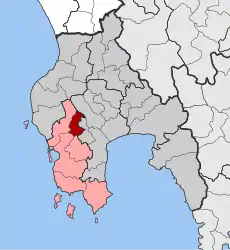 | |
| Coordinates: 37°01′N 21°47′E / 37.017°N 21.783°E | |
| Country | Greece |
| Administrative region | Peloponnese |
| Regional unit | Messenia |
| Municipality | Pylos-Nestor |
| • Municipal unit | 42.1 km2 (16.3 sq mi) |
| Population (2011)[1] | |
| • Municipal unit | 1,316 |
| • Municipal unit density | 31/km2 (81/sq mi) |
| Community | |
| • Population | 71 (2011) |
| Time zone | UTC+2 (EET) |
| • Summer (DST) | UTC+3 (EEST) |
| Vehicle registration | ΚΜ |
Papaflessas (Greek: Παπαφλέσσας, before 1915: Κοντογόνι - Kontogoni[2]) is a village and a former municipality in Messenia, Peloponnese, Greece. Since the 2011 local government reform it is part of the municipality Pylos-Nestor, of which it is a municipal unit.[3] The municipal unit has an area of 42.137 km2.[4] Population 1,316 (2011). The seat of the municipality was in Vlachopoulo.
It comprises five communities (τοπική κοινότητα): Vlachopoulo, Metamorfosi, Maniaki, Papaflessas, and Margeli. It was named after the Greek priest and revolutionary Papaflessas.
References
- 1 2 "Απογραφή Πληθυσμού - Κατοικιών 2011. ΜΟΝΙΜΟΣ Πληθυσμός" (in Greek). Hellenic Statistical Authority.
- ↑ "EETAA local government changes". Retrieved 26 June 2020.
- ↑ "ΦΕΚ B 1292/2010, Kallikratis reform municipalities" (in Greek). Government Gazette.
- ↑ "Population & housing census 2001 (incl. area and average elevation)" (PDF) (in Greek). National Statistical Service of Greece.
This article is issued from Wikipedia. The text is licensed under Creative Commons - Attribution - Sharealike. Additional terms may apply for the media files.