Paobelys | |
|---|---|
Village | |
 | |
 Paobelys Location in Lithuania  Paobelys Paobelys (Lithuania) | |
| Coordinates: 55°15′50″N 23°58′01″E / 55.26389°N 23.96694°E | |
| Country | |
| County | |
| Municipality | Kėdainiai district municipality |
| Eldership | Pelėdnagiai Eldership |
| Population (2011) | |
| • Total | 293 |
| Time zone | UTC+2 (EET) |
| • Summer (DST) | UTC+3 (EEST) |
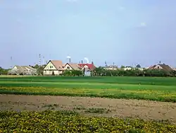
Paobelys (Paobelė, formerly Russian: Поабель, Polish: Poabele)[1] is a village in Kėdainiai district municipality of Kaunas County, in central Lithuania. According to the 2011 census, the village residents numbered 293.[2] It is located by the southeastern edge of Kėdainiai city, by the confluence of the Obelis and Nevėžis rivers, next to the crossroad of the Jonava-Šeduva (KK144) and Kėdainiai-Babtai roads. Also, the Šerkšnys river passes through the village.
History
In the beginning of the 20th century Paobelys was a small falwark.[1]
During the Soviet era, Paobelys was subsidiary settlement of the "Spike" kolkhoz.[3]
Demography
|
| |||||||||||||||||||||||||||||||||
| Source: 1902, 1923, 1959 & 1970, 1979, 1989, 2001, 2011 | ||||||||||||||||||||||||||||||||||
References
- 1 2 "Poabele". Geographical Dictionary of the Kingdom of Poland (in Polish). 15 pt. 2. Warszawa: Kasa im. Józefa Mianowskiego. 1902. p. 463.
- ↑ "2011 census". Statistikos Departamentas (Lithuania). Retrieved August 21, 2017.
- ↑ "Paobelys". Tarybų Lietuvos enciklopedija (in Lithuanian). Vol. 3. Vilnius: Vyriausioji enciklopedijų redakcija. 1987. p. 299.
This article is issued from Wikipedia. The text is licensed under Creative Commons - Attribution - Sharealike. Additional terms may apply for the media files.