Osternienburger Land | |
|---|---|
 Coat of arms | |
Location of Osternienburger Land within Anhalt-Bitterfeld district 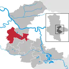 | |
 Osternienburger Land  Osternienburger Land | |
| Coordinates: 51°48′N 12°1′E / 51.800°N 12.017°E | |
| Country | Germany |
| State | Saxony-Anhalt |
| District | Anhalt-Bitterfeld |
| Government | |
| • Mayor (2016–23) | Stefan Hemmerling[1] (CDU) |
| Area | |
| • Total | 138.7 km2 (53.6 sq mi) |
| Elevation | 71 m (233 ft) |
| Population (2021-12-31)[2] | |
| • Total | 8,374 |
| • Density | 60/km2 (160/sq mi) |
| Time zone | UTC+01:00 (CET) |
| • Summer (DST) | UTC+02:00 (CEST) |
| Postal codes | 06386 |
| Dialling codes | 034909, 03496, 034973, 034977, 034979 |
| Vehicle registration | ABI |
| Website | www |
Osternienburger Land is a municipality in the district of Anhalt-Bitterfeld, in Saxony-Anhalt, Germany. It was formed on 1 January 2010 by the merger of the former municipalities Chörau, Diebzig, Dornbock, Drosa, Elsnigk, Großpaschleben, Kleinpaschleben, Libbesdorf, Micheln, Osternienburg, Reppichau, Trinum, Wulfen and Zabitz.[3] These 14 former municipalities are now Ortschaften or municipal divisions of Osternienburger Land.[4]
References
- ↑ Bürgermeisterwahlen in den Gemeinden, Endgültige Ergebnisse, Statistisches Landesamt Sachsen-Anhalt, accessed 8 July 2021.
- ↑ "Bevölkerung der Gemeinden – Stand: 31. Dezember 2021" (PDF) (in German). Statistisches Landesamt Sachsen-Anhalt. June 2022.
- ↑ Gebietsänderungen vom 01. Januar bis 31. Dezember 2010, Statistisches Bundesamt
- ↑ Hauptsatzung der Gemeinde Osternienburger Land, November 2020.
Towns and municipalities in the district of Anhalt-Bitterfeld | ||
|---|---|---|
Coat of arms | ||
This article is issued from Wikipedia. The text is licensed under Creative Commons - Attribution - Sharealike. Additional terms may apply for the media files.