Obergröningen | |
|---|---|
 Coat of arms | |
Location of Obergröningen within Ostalbkreis district 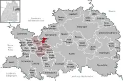 | |
 Obergröningen 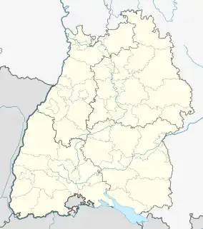 Obergröningen | |
| Coordinates: 48°53′40″N 09°54′33″E / 48.89444°N 9.90917°E | |
| Country | Germany |
| State | Baden-Württemberg |
| Admin. region | Stuttgart |
| District | Ostalbkreis |
| Government | |
| • Mayor (2016–24) | Jochen König[1] |
| Area | |
| • Total | 5.86 km2 (2.26 sq mi) |
| Elevation | 500 m (1,600 ft) |
| Population (2021-12-31)[2] | |
| • Total | 436 |
| • Density | 74/km2 (190/sq mi) |
| Time zone | UTC+01:00 (CET) |
| • Summer (DST) | UTC+02:00 (CEST) |
| Postal codes | 73569 |
| Dialling codes | 07975 |
| Vehicle registration | AA |
Obergröningen is a town in the German state of Baden-Württemberg, in Ostalbkreis district.
Demographics
Population development:[3]
|
References
- ↑ Aktuelle Wahlergebnisse, Staatsanzeiger, accessed 13 September 2021.
- ↑ "Bevölkerung nach Nationalität und Geschlecht am 31. Dezember 2021" [Population by nationality and sex as of December 31, 2021] (CSV) (in German). Statistisches Landesamt Baden-Württemberg. June 2022.
- ↑ "Obergröningen (Ostalbkreis, Baden-Württemberg, Deutschland) - Einwohnerzahlen, Grafiken, Karte, Lage, Wetter und Web-Informationen". www.citypopulation.de. Retrieved 2023-12-07.
This article is issued from Wikipedia. The text is licensed under Creative Commons - Attribution - Sharealike. Additional terms may apply for the media files.