Nossa Senhora do Pranto | |
|---|---|
 Village of Dornes | |
 Nossa Senhora do Pranto Location in Portugal | |
| Coordinates: 39°45′N 8°17′W / 39.75°N 8.28°W | |
| Country | |
| Region | Centro |
| Intermunic. comm. | Médio Tejo |
| District | Santarém |
| Municipality | Ferreira do Zêzere |
| Area | |
| • Total | 30.48 km2 (11.77 sq mi) |
| Population (2011) | |
| • Total | 1,089 |
| • Density | 36/km2 (93/sq mi) |
| Time zone | UTC±00:00 (WET) |
| • Summer (DST) | UTC+01:00 (WEST) |
Nossa Senhora do Pranto is a civil parish in the municipality of Ferreira do Zêzere, Portugal. It was formed in 2013 by the merger of the former parishes Paio Mendes and Dornes.[1] The population in 2011 was 1,089,[2] in an area of 30.48 km².[3]
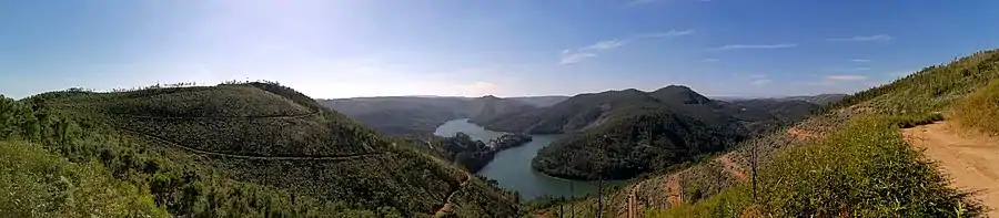
Panoramic of Dornes village and Zêzere river
References
- ↑ Diário da República. "Law nr. 11-A/2013, page 552 49" (pdf) (in Portuguese). Retrieved 22 July 2014.
- ↑ Instituto Nacional de Estatística (INE), Census 2011 results according to the 2013 administrative division of Portugal
- ↑ "Áreas das freguesias, concelhos, distritos e país". Archived from the original on 2018-11-05. Retrieved 2018-11-05.
This article is issued from Wikipedia. The text is licensed under Creative Commons - Attribution - Sharealike. Additional terms may apply for the media files.