Myrtle, West Virginia | |
|---|---|
 Myrtle, West Virginia  Myrtle, West Virginia | |
| Coordinates: 37°46′04″N 82°11′28″W / 37.76778°N 82.19111°W | |
| Country | United States |
| State | West Virginia |
| County | Mingo |
| Elevation | 722 ft (220 m) |
| Time zone | UTC-5 (Eastern (EST)) |
| • Summer (DST) | UTC-4 (EDT) |
| Area code(s) | 304 & 681 |
| GNIS feature ID | 1555186[1] |
Myrtle is an unincorporated community in Mingo County, West Virginia, United States. Myrtle is located on U.S. Route 119 and the Trace Fork, 8 miles (13 km) northeast of Williamson.[2] Myrtle had a post office, which opened on September 2, 1891, and closed on August 22, 1992.[3]
References
- ↑ "Myrtle". Geographic Names Information System. United States Geological Survey, United States Department of the Interior.
- ↑ Mingo County, West Virginia General Highway Map (PDF) (Map). West Virginia Department of Transportation. 2011. p. 1. Archived from the original (PDF) on April 25, 2012. Retrieved November 10, 2011.
- ↑ "Postmaster Finder - Post Offices by ZIP Code". United States Postal Service. Retrieved November 10, 2011.
Municipalities and communities of Mingo County, West Virginia, United States | ||
|---|---|---|
| City | 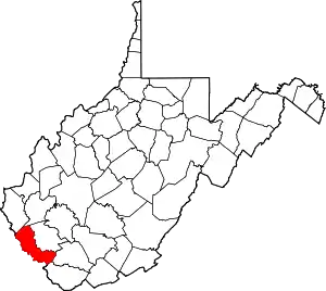 Mingo County map | |
| Towns | ||
| CDPs | ||
| Other communities |
| |
| Footnotes | ‡This populated place also has portions in an adjacent county or counties | |
This article is issued from Wikipedia. The text is licensed under Creative Commons - Attribution - Sharealike. Additional terms may apply for the media files.