| Mount Nila | |
|---|---|
 | |
| Highest point | |
| Elevation | 781 m (2,562 ft)[1] |
| Coordinates | 6°44′S 129°30′E / 6.73°S 129.50°E |
| Geography | |
| Location | Banda Sea, Indonesia |
| Geology | |
| Mountain type | Stratovolcano |
| Last eruption | May to June 1968 |
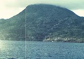
Nila volcano forms completely an isolated 5 × 6 km wide of island with the same name in the Barat Daya Islands of the Banda Sea, Indonesia. The volcano comprises a low caldera with its rims breach into the sea surface on the south and the east side. The dominantly andesitic volcano contains a young forested cone at the elevation of 781 m height.[1]
Mount Nila is a stratovolcano, and caused the abandonment of a Rumadai village when it erupted in 1968.
See also
References
- 1 2 "Nila". Global Volcanism Program. Smithsonian Institution. Retrieved 2021-06-24.
This article is issued from Wikipedia. The text is licensed under Creative Commons - Attribution - Sharealike. Additional terms may apply for the media files.