Morsiano | |
|---|---|
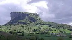 The particular shape of the Pietra di Bismantova in the province of Reggio Emilia | |
 Morsiano Location of Morsiano in Italy | |
| Coordinates: 44°18′18″N 10°30′23″E / 44.30500°N 10.50639°E | |
| Country | |
| Region | |
| Province | Reggio Emilia (RE) |
| Comune | Villa Minozzo |
| Area | |
| • Total | 5.5 km2 (2.1 sq mi) |
| Elevation | 720 m (2,360 ft) |
| Population | |
| • Total | 134 |
| • Density | 24/km2 (63/sq mi) |
| Demonym | Morsianesi |
| Time zone | UTC+1 (CET) |
| • Summer (DST) | UTC+2 (CEST) |
| Postal code | 40022 |
| Dialing code | 0542 |
| Website | Municipal website |
Morsiano is a hamlet administratively a frazione of Villa Minozzo in the province of Reggio Emilia. Located in the tuscany-emilia apennines near the Mount Cusna slopes. It is about 720 meters (2,360 feet) above sea level.
Overview
Morsiano has a population of 134 residents all year long (only the town not he entire frazione). Besides Morsiano there are other little villages which make up its frazione; the main ones are: Case Rossi, Monte Bore, Strinati, and Costalta.[3]
History
The hamlet is first mentioned in 1302 as being a part of the medieval comune of Toano. A census of the 18th century estimated the population to be 395. A little Marian niche dedicated to Our Lady dating back to the 1858 can be seen in the eastern part of this village.
References
- ↑ (in Italian) 2001 Census of the province of Reggio Emilia
- ↑ 134 (winter population), 420 (summer population)
- ↑ (in Italian) Infos at Villa Minozzo municipal website
See also
This article is issued from Wikipedia. The text is licensed under Creative Commons - Attribution - Sharealike. Additional terms may apply for the media files.