| Moorabool Victoria | |||||||||||||||
|---|---|---|---|---|---|---|---|---|---|---|---|---|---|---|---|
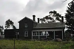 The former railway station | |||||||||||||||
 Moorabool | |||||||||||||||
| Coordinates | 38°04′S 144°18′E / 38.067°S 144.300°E | ||||||||||||||
| Population | 94 (SAL 2021)[1] | ||||||||||||||
| Postcode(s) | 3221/3213 | ||||||||||||||
| LGA(s) | City of Greater Geelong | ||||||||||||||
| State electorate(s) | Lara | ||||||||||||||
| Federal division(s) | Corio | ||||||||||||||
| |||||||||||||||
Moorabool (/mˈʊrəbʊl/) is a bounded rural locality of the City of Greater Geelong local government area in Victoria, Australia.
History
Moorabool Post Office opened on 1 October 1861 and closed in 1960.[2]
In 2021, the Victorian Big Battery began operations at Moorabool.
Heritage listed sites
Moorabool contains a number of heritage listed sites, including:
- Geelong-Ballarat railway line, Cowies Creek Rail Bridge No. 2[3]
- 275 Ballan Road, Moorabool railway station[4]
- Geelong-Ballarat railway line, Moorabool River Railway Viaduct[5]
References
- ↑ Australian Bureau of Statistics (28 June 2022). "Moorabool (suburb and locality)". Australian Census 2021 QuickStats. Retrieved 28 June 2022.
- ↑ Premier Postal History, Post Office List, retrieved 11 April 2008
- ↑ "Cowies Creek Rail Bridge No. 2 (H2241)". Victorian Heritage Register. Heritage Victoria. Retrieved 4 July 2014.
- ↑ "Former Moorabool Railway Station (H1579)". Victorian Heritage Register. Heritage Victoria. Retrieved 4 July 2014.
- ↑ "Railway Viaduct (H1105)". Victorian Heritage Register. Heritage Victoria. Retrieved 4 July 2014.
External links
![]() Media related to Moorabool, Victoria at Wikimedia Commons
Media related to Moorabool, Victoria at Wikimedia Commons
Localities in the City of Greater Geelong | ||
|---|---|---|
| City | | |
| Town |
| |
| Locality | ||
^ - Territory divided with another LGA | ||
This article is issued from Wikipedia. The text is licensed under Creative Commons - Attribution - Sharealike. Additional terms may apply for the media files.