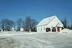
Mille-Isles | |
|---|---|
 | |
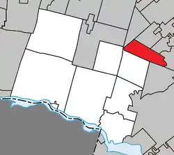 Location within Argenteuil RCM | |
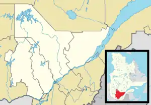 Mille-Isles Location in central Quebec | |
| Coordinates: 45°49′N 74°13′W / 45.82°N 74.22°W[1] | |
| Country | Canada |
| Province | Quebec |
| Region | Laurentides |
| RCM | Argenteuil |
| Settled | 1850s |
| Constituted | July 1, 1855 |
| Government | |
| • Mayor | Howard Sauvé |
| • Federal riding | Argenteuil—Papineau—Mirabel |
| • Prov. riding | Argenteuil |
| Area | |
| • Total | 61.94 km2 (23.92 sq mi) |
| • Land | 58.73 km2 (22.68 sq mi) |
| Population (2021)[3] | |
| • Total | 1,721 |
| • Density | 29.3/km2 (76/sq mi) |
| • Pop 2016-2021 | |
| • Dwellings | 950 |
| Time zone | UTC−5 (EST) |
| • Summer (DST) | UTC−4 (EDT) |
| Postal code(s) | |
| Area code(s) | 450 and 579 |
| Highways | |
| Website | mille-isles |
Mille-Isles is a municipality in the Laurentides region of Quebec, Canada, part of the Argenteuil Regional County Municipality, west of Saint-Jérôme.
Mille-Isles is in the Laurentian Hills, crossed by rivers and dotted with fish-filled lakes.[4]
History
The municipality is named after the old Mille-Isles Seigneury, which originally straddled the Mille Îles River (the seigneury uses the old spelling, whereas the river uses the modern word that substitutes a circumflex for the "s"). In 1683, the seigneury was granted to Michel-Sidrac Dugué de Boisbriand (circa 1638-1688), who was governor of Montreal in 1670. In 1714, it was inherited by Charles-Gaspard Piot de Langloiserie (circa 1655-1715) and Jean Petit (1663-1720), husbands of Marie-Thérèse Dugué and Charlotte Dugué respectively, daughters of the first lord. In 1752, additional land in the extreme north-west of the Mille-Isles Seigneury was given to Eustache Lambert Dumont and it is within this part that the municipality is located.[4]
The first settlers were from Ireland and arrived around 1850. The municipality was officially founded in 1855, following separation from the parish of Saint-Jérôme.[4]
Demographics
| 2021 | 2016 | 2011 | |
|---|---|---|---|
| Population | 1,721 (9.8% from 2016) | 1,567 (-3.8% from 2011) | 1,629 (+10.1% from 2006) |
| Land area | 58.73 km2 (22.68 sq mi) | 59.82 km2 (23.10 sq mi) | 60.82 km2 (23.48 sq mi) |
| Population density | 29.3/km2 (76/sq mi) | 26.2/km2 (68/sq mi) | 26.8/km2 (69/sq mi) |
| Median age | 48.0 (M: 50.0, F: 46.0) | 46.6 (M: 47.9, F: 45.3) | 44.3 (M: 44.6, F: 43.9) |
| Private dwellings | 950 (total) | 907 (total) | 912 (total) |
| Median household income | $61,568 | $n/a |
|
| ||||||||||||||||||||||||||||||||||||
| Source: Statistics Canada[10] | |||||||||||||||||||||||||||||||||||||
Mother tongue:
- English as first language: 28%
- French as first language: 69%
- English and French as first language: 1%
- Other as first language: 2%
Local government
List of former mayors:
- Richard Cyr (... –2005)
- John Carson Collins (2005–2009)
- Yvon Samson (2009–2013)
- Michel Boyer (2013–2017
- Howard Sauvé (2017–present)
Education
The Commission scolaire de la Rivière-du-Nord (CSRDN) operates Francophone public schools:[11]
- École primaire Bellefeuille in Saint-Jérôme
- École secondaire Émilien-Frenette in Saint-Jérôme and École polyvalente Lavigne in Lachute
Sir Wilfrid Laurier School Board operates English-language public schools. Schools serving the town:
- Morin Heights Elementary School in Morin-Heights serves most of the town[12]
- Laurentia Elementary School in Saint-Jérôme serves a portion of the town[13]
- Laurentian Regional High School in Lachute[14]
See also
References
- ↑ "Banque de noms de lieux du Québec: Reference number 41163". toponymie.gouv.qc.ca (in French). Commission de toponymie du Québec.
- 1 2 "Répertoire des municipalités: Mille-Isles". www.mamh.gouv.qc.ca (in French). Ministère des Affaires municipales et de l'Habitation. Retrieved 17 May 2022.
- 1 2 "Mille-Isles, Municipalité (MÉ) Census Profile, 2021 Census of Population". www12.statcan.gc.ca. Government of Canada - Statistics Canada. Retrieved 17 May 2022.
- 1 2 3 "Mille-Isles (Municipalité)" (in French). Commission de toponymie du Québec. Retrieved 2009-03-10.
- ↑ "2021 Community Profiles". 2021 Canadian Census. Statistics Canada. February 4, 2022. Retrieved 2022-05-12.
- ↑ "2016 Community Profiles". 2016 Canadian Census. Statistics Canada. August 12, 2021. Retrieved 2022-01-26.
- ↑ "2011 Community Profiles". 2011 Canadian Census. Statistics Canada. March 21, 2019. Retrieved 2022-01-26.
- ↑ "2006 Community Profiles". 2006 Canadian Census. Statistics Canada. August 20, 2019.
- ↑ "2001 Community Profiles". 2001 Canadian Census. Statistics Canada. July 18, 2021.
- ↑ 1996, 2001, 2006, 2011 census
- ↑ "Trouver une école ou un centre." Commission scolaire de la Rivière-du-Nord. Retrieved on September 24, 2017. For attendance boundary information, click "Par bassin d'école"
- ↑ "MORIN HEIGHTS ELEMENTARY ZONE." Sir Wilfrid Laurier School Board. Retrieved on September 16, 2017.
- ↑ "LAURENTIA ELEMENTARY ZONE." Sir Wilfrid Laurier School Board. Retrieved on September 4, 2017.
- ↑ "LAURENTIAN REGIONAL HS ZONE." Sir Wilfrid Laurier School Board. Retrieved on September 4, 2017.
External links
 Media related to Mille-Isles at Wikimedia Commons
Places adjacent to Mille-Isles | |
|---|---|
| Towns | |
|---|---|
| Municipalities | |
| Townships | |
| Villages | |
| |