| Matebian | |
|---|---|
| Matebean | |
 | |
| Highest point | |
| Elevation | 2,316 m (7,598 ft)[1] |
| Coordinates | 8°38′26.16″S 126°35′48.84″E / 8.6406000°S 126.5969000°E |
| Geography | |
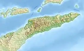 Matebian Location in East Timor | |
| Location | Baucau District, East Timor |
Matebian or Matebean is the third highest mountain in Timor Leste, after Ramelau (Tatamailau).
Geography
The mountain is located in Baucau District. With an elevation of 2,316 metres (7,598 ft) it is among the ultra-prominent peaks of the Malay archipelago.
Gallery
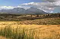 Harvested rice fields of Matebian, Timor-Leste
 View across the Seiçal River to Matebian Mountain, East Timor
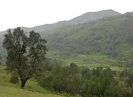
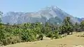 Matebian, East Timor
References
- ↑ Timor Leste: Politics, History, and Culture, Andrea Katalin Molnar, Routledge, 2009, Google books Retrieved 2015-12-24
- ↑ Matebean Mane, Climbing the Mountains of Indonesia. Retrieved 2014-04-11.
- ↑ Around Baucau Archived 2014-04-13 at the Wayback Machine, Lonely Planet. Retrieved 2014-04-11.
![]() Media related to Matebian at Wikimedia Commons
Media related to Matebian at Wikimedia Commons
This article is issued from Wikipedia. The text is licensed under Creative Commons - Attribution - Sharealike. Additional terms may apply for the media files.