Marchaux | |
|---|---|
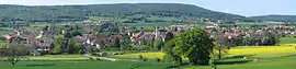
Part of Marchaux-Chaudefontaine | |
 | |
Location of Marchaux | |
 Marchaux 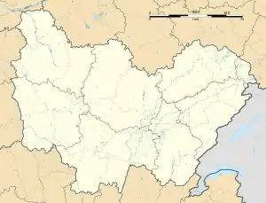 Marchaux | |
| Coordinates: 47°19′27″N 6°08′01″E / 47.3242°N 6.1336°E | |
| Country | France |
| Region | Bourgogne-Franche-Comté |
| Department | Doubs |
| Arrondissement | Besançon |
| Canton | Besançon-4 |
| Commune | Marchaux-Chaudefontaine |
| Area 1 | 10.06 km2 (3.88 sq mi) |
| Population (2015)[1] | 1,235 |
| • Density | 120/km2 (320/sq mi) |
| Time zone | UTC+01:00 (CET) |
| • Summer (DST) | UTC+02:00 (CEST) |
| Postal code | 25640 |
| Elevation | 279–530 m (915–1,739 ft) |
| 1 French Land Register data, which excludes lakes, ponds, glaciers > 1 km2 (0.386 sq mi or 247 acres) and river estuaries. | |
Marchaux (French pronunciation: [maʁʃo]) is a former commune in the Doubs department in the Bourgogne-Franche-Comté region in eastern France. On 1 January 2018, it was merged into the new commune of Marchaux-Chaudefontaine.[2]
Geography
Marchaux lies 10 km (6.2 mi) from Besançon at the edge of the forest of Chailluz.
It is 2 km (1.2 mi) from the exit from the A36 freeway.
Population
| Year | Pop. | ±% |
|---|---|---|
| 1962 | 305 | — |
| 1968 | 379 | +24.3% |
| 1975 | 556 | +46.7% |
| 1982 | 688 | +23.7% |
| 1990 | 806 | +17.2% |
| 1999 | 937 | +16.3% |
| 2008 | 1,030 | +9.9% |
| 2012 | 1,193 | +15.8% |
See also
References
- ↑ Téléchargement du fichier d'ensemble des populations légales en 2015, INSEE
- ↑ Arrêté préfectoral 4 December 2017 (in French)
External links
Wikimedia Commons has media related to Marchaux.
This article is issued from Wikipedia. The text is licensed under Creative Commons - Attribution - Sharealike. Additional terms may apply for the media files.