Maiji
麦积区 | |
|---|---|
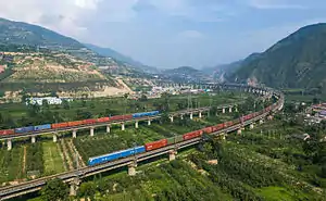
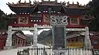
Clockwise from top: Maijishan Grottoes, pedestrian street in Tongshui City, the gate to Jingtu Temple, the Longhai Railway in Yuanlong, and scenery off the Baoji-Tianshui Expressway. | |
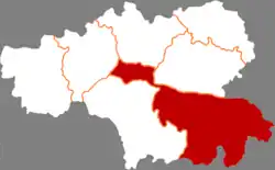 Maiji in Tianshui | |
.png.webp) Tianshui in Gansu | |
| Coordinates: 34°34′16″N 105°53′20″E / 34.57111°N 105.88889°E | |
| Country | People's Republic of China |
| Province | Gansu |
| Prefecture-level city | Tianshui |
| Area | |
| • County | 3,452 km2 (1,333 sq mi) |
| Population (2018) | 650,000 |
| • Urban | 200,000 |
| Time zone | UTC+8 (CST) |
| Postal code | 741020 |
| Website | www |


.jpg.webp)
Maiji District (simplified Chinese: 麦积区; traditional Chinese: 麥積區; pinyin: Màijī Qū) is a district of the prefecture-level city of Tianshui in the southeast of Gansu Province, China, bordering Shaanxi Province to the east. It is best known for, and named after, the Maijishan Grottoes.[1] Before 2005 it was called Beidao District.[2]
Maiji District is subdivided in 17 towns (containing 379 villages), 3 subdistricts (containing 35 residential communities). 69% of the population is rural. 68% of the district's area is covered in forest.[3]
Administrative divisions
Maiji District is divided to 3 subdistricts, 17 towns and 6 others.
- Subdistricts
- Daobei Subdistrict (道北街道)
- Beidaobu Subdistrict (北道埠街道)
- Qiaonan Subdistrict (桥南街道)
- Towns
The towns of Weinan, Zhongtan and Shifo together are also known under the name Sanyuanchuan (三阳川).[4]
|
|
|
- Others
- Tianshui Economic Development Zone (水经济开发区)
- Tianshui High-tech Industrial Park (水市高新技术工业园)
- Tianshui City Agricultural High-tech Demonstration Zone (水市农业高新技术示范区)
- Sanyang Industrial Demonstration Zone (三阳工业示范区)
- Nianpu Industrial Demonstration Zone (廿铺工业示范区)
- Dongkehe Industrial Park (东柯河工业园区)
Climate
| Climate data for Maiji (1991–2020 normals, extremes 1981–2010) | |||||||||||||
|---|---|---|---|---|---|---|---|---|---|---|---|---|---|
| Month | Jan | Feb | Mar | Apr | May | Jun | Jul | Aug | Sep | Oct | Nov | Dec | Year |
| Record high °C (°F) | 14.7 (58.5) |
21.4 (70.5) |
29.9 (85.8) |
33.4 (92.1) |
34.5 (94.1) |
36.3 (97.3) |
37.2 (99.0) |
35.9 (96.6) |
36.3 (97.3) |
28.6 (83.5) |
22.2 (72.0) |
14.0 (57.2) |
37.2 (99.0) |
| Mean daily maximum °C (°F) | 4.8 (40.6) |
8.7 (47.7) |
14.7 (58.5) |
21.1 (70.0) |
24.9 (76.8) |
28.3 (82.9) |
29.9 (85.8) |
28.7 (83.7) |
23.2 (73.8) |
17.5 (63.5) |
11.6 (52.9) |
5.9 (42.6) |
18.3 (64.9) |
| Daily mean °C (°F) | −1.6 (29.1) |
2.3 (36.1) |
7.8 (46.0) |
13.6 (56.5) |
17.6 (63.7) |
21.3 (70.3) |
23.6 (74.5) |
22.5 (72.5) |
17.4 (63.3) |
11.4 (52.5) |
5.1 (41.2) |
−0.7 (30.7) |
11.7 (53.0) |
| Mean daily minimum °C (°F) | −5.9 (21.4) |
−2.4 (27.7) |
2.3 (36.1) |
7.1 (44.8) |
11.2 (52.2) |
15.4 (59.7) |
18.3 (64.9) |
17.6 (63.7) |
13.2 (55.8) |
7.1 (44.8) |
0.6 (33.1) |
−5.1 (22.8) |
6.6 (43.9) |
| Record low °C (°F) | −15.1 (4.8) |
−14.1 (6.6) |
−9.7 (14.5) |
−3.4 (25.9) |
0.5 (32.9) |
5.3 (41.5) |
9.2 (48.6) |
9.0 (48.2) |
2.7 (36.9) |
−5.1 (22.8) |
−12.1 (10.2) |
−17.6 (0.3) |
−17.6 (0.3) |
| Average precipitation mm (inches) | 3.6 (0.14) |
6.0 (0.24) |
16.7 (0.66) |
35.5 (1.40) |
57.3 (2.26) |
71.5 (2.81) |
97.6 (3.84) |
94.6 (3.72) |
78.3 (3.08) |
45.9 (1.81) |
11.4 (0.45) |
3.0 (0.12) |
521.4 (20.53) |
| Average precipitation days (≥ 0.1 mm) | 4.2 | 4.3 | 6.3 | 7.7 | 10.0 | 10.5 | 11.3 | 10.6 | 12.1 | 10.2 | 5.3 | 2.9 | 95.4 |
| Average snowy days | 7.1 | 5.2 | 2.3 | 0.3 | 0 | 0 | 0 | 0 | 0 | 0.1 | 2.3 | 4.5 | 21.8 |
| Average relative humidity (%) | 64 | 62 | 58 | 58 | 62 | 66 | 69 | 72 | 77 | 78 | 74 | 68 | 67 |
| Mean monthly sunshine hours | 137.4 | 130.8 | 167.6 | 202.9 | 214.9 | 205.4 | 214.4 | 198.4 | 133.7 | 124.6 | 128.1 | 138.8 | 1,997 |
| Percent possible sunshine | 44 | 42 | 45 | 52 | 50 | 48 | 49 | 48 | 36 | 36 | 42 | 46 | 45 |
| Source: China Meteorological Administration[5][6] | |||||||||||||
Economy
Huaniu apples are a speciality agricultural product grown in the area.[7] Other produce grown include forest fruits, vegetables and grapes.[8][9][3]
Industries include machinery manufacturing, electrical appliance production, IT, medicine, food production, and building materials.
See also
References
- ↑ "甘肃省天水市麦积区 麦积区历史沿革_安宽带 提供联通宽带、移动宽带、电信宽带资讯!".
- ↑ "天水市旅游详细介绍,行政区划、人口面积、交通地图、特产小吃、风景图片、名胜古迹、景区景点等". www.365135.com. Retrieved 2021-01-26.
- 1 2 "麦积概况". www.maiji.gov.cn.
- ↑ 杨东晨 (2017-06-01). 中华文明探源 (in Chinese). Beijing Book Co. Inc. ISBN 978-7-5518-1491-1.
- ↑ 中国气象数据网 – WeatherBk Data (in Simplified Chinese). China Meteorological Administration. Retrieved 27 August 2023.
- ↑ 中国气象数据网 (in Simplified Chinese). China Meteorological Administration. Retrieved 27 August 2023.
- ↑ "Tianshui Huaniu apples". gansu.chinadaily.com.cn.
- ↑ "麦积区农民为"下曲葡萄""铺"网防鸟啄(组图)--天水在线". www.tianshui.com.cn.
- ↑ ""中华名果"下曲葡萄 - 天天天水网 - 天水日报社主办 - 天水最权威的新闻门户网站". www.tsrb.com.cn.