Möhrendorf | |
|---|---|
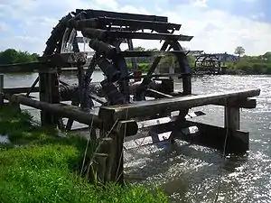 Historical water wheels on the Regnitz river | |
 Coat of arms | |
Location of Möhrendorf within Erlangen-Höchstadt district 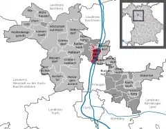 | |
 Möhrendorf  Möhrendorf | |
| Coordinates: 49°38′N 11°00′E / 49.633°N 11.000°E | |
| Country | Germany |
| State | Bavaria |
| Admin. region | Mittelfranken |
| District | Erlangen-Höchstadt |
| Subdivisions | 3 districts |
| Government | |
| • Mayor (2020–26) | Thomas Fischer[1] (CSU) |
| Area | |
| • Total | 13.16 km2 (5.08 sq mi) |
| Elevation | 272 m (892 ft) |
| Population (2022-12-31)[2] | |
| • Total | 4,912 |
| • Density | 370/km2 (970/sq mi) |
| Time zone | UTC+01:00 (CET) |
| • Summer (DST) | UTC+02:00 (CEST) |
| Postal codes | 91096 |
| Dialling codes | 09131, 09133 |
| Vehicle registration | ERH |
| Website | www.moehrendorf.de |
Möhrendorf is a town in the district of Erlangen-Höchstadt, in Bavaria, Germany. It lies on the river Regnitz and the Rhine-Main-Danube Canal.
References
- ↑ Liste der ersten Bürgermeister/Oberbürgermeister in kreisangehörigen Gemeinden, Bayerisches Landesamt für Statistik, 15 July 2021.
- ↑ Genesis Online-Datenbank des Bayerischen Landesamtes für Statistik Tabelle 12411-003r Fortschreibung des Bevölkerungsstandes: Gemeinden, Stichtag (Einwohnerzahlen auf Grundlage des Zensus 2011)
Towns and municipalities in Erlangen-Höchstadt | ||
|---|---|---|
Coat of Arms of Erlangen-Höchstadt district | ||
This article is issued from Wikipedia. The text is licensed under Creative Commons - Attribution - Sharealike. Additional terms may apply for the media files.