| Lynde Creek | |
|---|---|
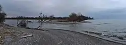 Lynde Creek emptying into Lake Ontario | |
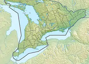 Location of the mouth of Lynde Creek in southern Ontario | |
| Location | |
| Country | Canada |
| Province | Ontario |
| Region | Central Ontario |
| Regional Municipality | Durham |
| Municipalities | |
| Physical characteristics | |
| Source | Chalk Lake |
| • location | Scugog |
| • coordinates | 44°01′18″N 79°02′17″W / 44.02167°N 79.03806°W |
| • elevation | 287 m (942 ft) |
| Mouth | Lake Ontario |
• location | Whitby |
• coordinates | 43°50′43″N 78°57′09″W / 43.84528°N 78.95250°W |
• elevation | 74 m (243 ft) |
| Basin size | 132.19 km2 (51.04 sq mi) |
| Basin features | |
| River system | Great Lakes Basin |
Lynde Creek is a stream in the municipalities of Whitby and Scugog, Regional Municipality of Durham, in the Greater Toronto Area of Ontario, Canada.[1] It is in the Great Lakes Basin, is a tributary of Lake Ontario, and is under the auspices of the Central Lake Ontario Conservation Authority.[2] The creek begins on the Oak Ridges Moraine in geographic Reach Township[3] in the municipality of Scugog, and flows south to its mouth in the southwest of the town of Whitby. Portions of the 132.19-square-kilometre (51.04 sq mi) watershed[4] also extend into the town of Ajax, the city of Pickering and the municipality of Uxbridge.[2]
References
- ↑ "Lynde Creek". Geographical Names Data Base. Natural Resources Canada. Retrieved 2015-12-05.
- 1 2 "Lynde Creek Watershed Plan" (PDF). Central Lake Ontario Conservation Authority. May 2012. Retrieved 2015-12-05.
- ↑ "Township of Reach" (JPG). 1880 Map of Ontario Counties - The Canadian County Atlas Digital Project. McGill University. Retrieved 2015-12-05.
- ↑ "Land & Water Conservation". Central Lake Ontario Conservation Authority. Archived from the original on 2015-12-08. Retrieved 2015-12-05.
This article is issued from Wikipedia. The text is licensed under Creative Commons - Attribution - Sharealike. Additional terms may apply for the media files.