Long Lane, Missouri | |
|---|---|
 Long Lane  Long Lane | |
| Coordinates: 37°36′41″N 92°54′34″W / 37.61139°N 92.90944°W | |
| Country | United States |
| State | Missouri |
| County | Dallas |
| Elevation | 1,135 ft (346 m) |
| Time zone | UTC-6 (Central (CST)) |
| • Summer (DST) | UTC-5 (CDT) |
| ZIP code | 65590[1] |
| Area code | 417 |
| GNIS feature ID | 721551[2] |
Long Lane is an unincorporated community in Dallas County, Missouri, United States.[2] It is located on Route 32, eleven miles east of Buffalo.
Long Lane is part of the Springfield, Missouri Metropolitan Statistical Area.
History
Long Lane was founded in 1845.[3] The community was named for the relatively long road leading to the original town site.[4] A post office called Long Lane has been in operation since 1850.[5]
Features
The town contains the Long Lane Volunteer Fire Department.[6]
School
Long Lane students attend school in Buffalo Missouri due to school consolidation closing the elementary school in town.
References
- ↑ "Long Lane ZIP Code". zipdatamaps.com. 2022. Retrieved November 30, 2022.
- 1 2 U.S. Geological Survey Geographic Names Information System: Long Lane
- ↑ Earngey, Bill (1995). Missouri Roadsides: The Traveler's Companion. University of Missouri Press. p. 28. ISBN 9780826210210.
- ↑ "Dallas County Place Names, 1928-1945". The State Historical Society of Missouri. Retrieved September 14, 2016.
- ↑ "Post Offices". Jim Forte Postal History. Retrieved September 25, 2016.
- ↑ U.S. Geological Survey Geographic Names Information System: Long Lane Volunteer Fire Department
Municipalities and communities of Dallas County, Missouri, United States | ||
|---|---|---|
| Cities | 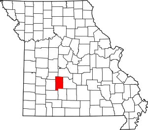 Map of Missouri highlighting Dallas County | |
| Village | ||
| Townships | ||
| CDP | ||
| Other unincorporated communities | ||
| Ghost towns | ||
| Footnotes | ‡This populated place also has portions in an adjacent county or counties | |
This article is issued from Wikipedia. The text is licensed under Creative Commons - Attribution - Sharealike. Additional terms may apply for the media files.