| Loir | |
|---|---|
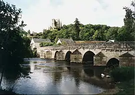 The Loir in Lavardin | |
.png.webp) | |
| Etymology | From Gaulish ledo, "flow"[1] |
| Nickname(s) | Loir sans E ("Loir-without-E")[2][3] |
| Native name | Le Loir (French) |
| Location | |
| Country | France |
| Physical characteristics | |
| Source | |
| • location | Perche |
| • elevation | 150 m (490 ft) |
| Mouth | |
• location | Sarthe |
• coordinates | 47°33′27″N 0°31′35″W / 47.55750°N 0.52639°W |
| Length | 319 km (198 mi) |
| Basin size | 8,270 km2 (3,190 sq mi) |
| Discharge | |
| • average | 33 m3/s (1,200 cu ft/s) |
| Basin features | |
| Progression | Sarthe→ Maine→ Loire→ Atlantic Ocean |
The Loir (French pronunciation: [lwaʁ] ⓘ) is a 319 km (198 mi) long river in western France.[4] It is a left tributary of the Sarthe. Its source is in the Eure-et-Loir department, north of Illiers-Combray. It joins the river Sarthe in Briollay, north of the city of Angers.
It is indirectly a tributary of the Loire, and runs roughly parallel to it and slightly north of it for much of its length, and so might be regarded as a Yazoo type river.
Departments and towns crossed include
Tributaries include
References
- ↑ Nègre, Ernest (1990). Toponymie générale de la France. ISBN 9782600028837.
- ↑ "Noms de départements et de Régions | Orthodidacte". 15 February 2018.
- ↑ Maubeuge, Pierre L. (December 6, 1996). Comme une odeur de pétrole--: la recherche du pétrole en France des origines à 1945. Pierron. ISBN 9782708501485 – via Google Books.
- ↑ Sandre. "Fiche cours d'eau - Loir (M1--0160)".
Wikimedia Commons has media related to Loir.
This article is issued from Wikipedia. The text is licensed under Creative Commons - Attribution - Sharealike. Additional terms may apply for the media files.