| Linkins Lake | |
|---|---|
 Linkins Lake | |
 Linkins Lake  Linkins Lake | |
| Location | Pitkin County, Colorado, United States |
| Coordinates | 39°07′42″N 106°35′19″W / 39.128463°N 106.588643°W |
| Type | Glacial |
| Primary outflows | Creek to Roaring Fork River |
| Basin countries | United States |
| Max. length | 0.20 mi (0.32 km) |
| Max. width | 0.13 mi (0.21 km) |
| Surface elevation | 12,008 ft (3,660 m) |
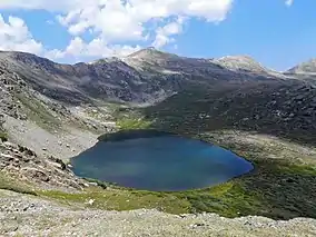
Linkins Lake is an alpine lake in Pitkin County, Colorado, United States, located high in the Sawatch Range in the Hunter-Fryingpan Wilderness of White River National Forest. The lake is accessible via a 0.6 miles (0.97 km) trail from State Highway 82 west of Independence Pass.[1][2]
References
- ↑ "Linkins Lake". Geographic Names Information System. United States Geological Survey, United States Department of the Interior. Retrieved August 21, 2012.
- ↑ Aspen/Independence Pass 127 (Map) (2005 ed.). Trails Illustrated. National Geographic Society. 1984.
This article is issued from Wikipedia. The text is licensed under Creative Commons - Attribution - Sharealike. Additional terms may apply for the media files.