Latacunga Canton | |
|---|---|
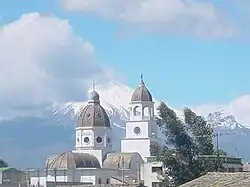 Guaytacama with Cotopaxi volcano in the background | |
.svg.png.webp) Latacunga Canton in Cotopaxi Province | |
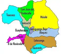 Parishes of Latacunga Canton | |
| Coordinates: 0°56′S 78°37′W / 0.933°S 78.617°W | |
| Country | |
| Province | Cotopaxi Province |
| Capital | Latacunga |
| Area | |
| • Total | 1,494 km2 (577 sq mi) |
| Population (2022 census)[1] | |
| • Total | 217,261 |
| • Density | 150/km2 (380/sq mi) |
| Time zone | UTC-5 (ECT) |
Latacunga Canton is one of seven cantons of the Cotopaxi Province in Ecuador. Its population at the 2001 census was 143,979.[2] Its capital is the town of Latacunga.
Subdivision
The capital of the canton consists of the following urban parishes: Eloy Alfaro (San Felipe), Ignacio Flores (La Laguna), Juan Montalvo (San Sebastián), La Matríz, San Buenaventura.
The canton is divided into the following rural parishes:
- Toacaso
- San Juan de Pastocalle
- Mulaló
- Tanicuchí
- Guaytacama
- Alaques
- Poaló
- Once de Noviembre
- Belisario Quevedo
- Joseguango Bajo
Demographics
Ethnic groups as of the Ecuadorian census of 2010:[3]
- Mestizo 86.4%
- Indigenous 8.5%
- White 2.7%
- Afro-Ecuadorian 1.5%
- Montubio 0.7%
- Other 0.1%
References
- ↑ Citypopulation.de Population and area of Latacunga Canton
- ↑ Cantons of Ecuador at statoids.com
- ↑ "Resultados".
External links
This article is issued from Wikipedia. The text is licensed under Creative Commons - Attribution - Sharealike. Additional terms may apply for the media files.