Krusdorf | |
|---|---|
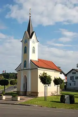 Chapel in Krusdorf | |
 Coat of arms | |
 Krusdorf Location within Austria | |
| Coordinates: 46°50′00″N 15°52′00″E / 46.83333°N 15.86667°E | |
| Country | Austria |
| State | Styria |
| District | Südoststeiermark |
| Government | |
| • Mayor | Rudolf Lackner (ÖVP) |
| Area | |
| • Total | 5.95 km2 (2.30 sq mi) |
| Elevation | 270 m (890 ft) |
| Population (1 January 2016)[1] | |
| • Total | 398 |
| • Density | 67/km2 (170/sq mi) |
| Time zone | UTC+1 (CET) |
| • Summer (DST) | UTC+2 (CEST) |
| Postal code | 8345 |
| Area code | +43 3473 |
| Vehicle registration | FB |
| Website | www.krusdorf.steiermark.at |
Krusdorf is a former municipality in the district of Südoststeiermark in the Austrian state of Styria. Since the 2015 Styria municipal structural reform, it is part of the municipality Straden.[2]
Population
| Year | Pop. | ±% |
|---|---|---|
| 1869 | 495 | — |
| 1880 | 507 | +2.4% |
| 1890 | 510 | +0.6% |
| 1900 | 490 | −3.9% |
| 1910 | 469 | −4.3% |
| 1923 | 471 | +0.4% |
| 1934 | 503 | +6.8% |
| 1939 | 446 | −11.3% |
| 1951 | 475 | +6.5% |
| 1961 | 406 | −14.5% |
| 1971 | 446 | +9.9% |
| 1981 | 445 | −0.2% |
| 1991 | 430 | −3.4% |
| 2001 | 394 | −8.4% |
| 2013 | 394 | +0.0% |
References
This article is issued from Wikipedia. The text is licensed under Creative Commons - Attribution - Sharealike. Additional terms may apply for the media files.