| Kondoma | |
|---|---|
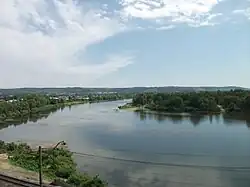 The Kondoma near Osinniki in June 2011 | |
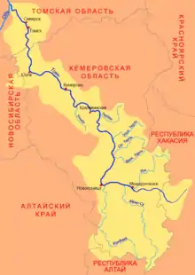 Map of the Tom River watershed | |
| Native name | Кондома (Russian) |
| Location | |
| Country | Russia |
| Federal subject | Kemerovo Oblast |
| Cities | Osinniki, Tashtagol, Kaltan |
| Physical characteristics | |
| Mouth | Tom |
• coordinates | 53°44′43″N 87°11′26″E / 53.7454°N 87.1906°E |
| Length | 392 km (244 mi) |
| Basin size | 8,270 km2 (3,190 sq mi) |
| Basin features | |
| Progression | Tom→ Ob→ Kara Sea |
| Tributaries | |
| • left | Antrop |
| • right | Mundybash |
The Kondoma (Russian: Ко́ндома; Shor: Қондум, Qondum) is a river in Kemerovo Oblast, Russia. It is left tributary of the Tom. It is 392 kilometres (244 mi) long, with a drainage basin of 8,270 square kilometres (3,190 sq mi).[1] The towns of Tashtagol, Osinniki and Kaltan are situated by the Kondoma. Its main tributaries are the Mundybash, Tesh, and Telbes rivers. It flows into the Tom in Novokuznetsk.
References
- ↑ "Река КОНДОМА in the State Water Register of Russia". textual.ru (in Russian).
This article is issued from Wikipedia. The text is licensed under Creative Commons - Attribution - Sharealike. Additional terms may apply for the media files.