| Klosterweg | |
|---|---|
 Klosterweg waymark | |
| Length | 17 km (11 mi) |
| Location | Rhineland-Palatinate, Germany |
| Trailheads | Rengsdorf, Waldbreitbach |
| Use | Hiking |
| Elevation change | 1,513 m (4,964 ft) |
| Highest point | Kurtscheid, 389 m (1,276 ft) |
| Lowest point | Niederbreitbach, 130 m (430 ft) |
| Difficulty | Easy |
| Season | All year |
| Website | http://www.der-klosterweg.de/ |
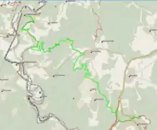
The Klosterweg is a hiking trail in Rhineland-Palatinate, Germany. The trail is 17 km (11 mi) long and connects Rengsdorf via Kurtscheid with Waldbreitbach leading through the Westerwald forest.
Description
Klosterweg
Leading through the Rhine-Westerwald Nature Park the trail connects two popular long distance trails in Rhineland-Palatinate, the Rheinsteig in Rengsdorf and the Westerwald-Steig in Waldbreitbach. The trail was opened in May 2009. In October 2009 the Klosterweg received the quality label Premiumweg.[1]
The Klosterweg leads along following sights:
- St. Kastor church in Rengsdorf
- Evangelic church in Rengsdorf
- Römergraben (a medieval landwehr in Rengsdorf
- Spa park in Ehlscheid
- Church Heilige Schutzengel in Kurtscheid
- Mutter Rosa monument
- Fockenbach valley
- Church Maria Himmelfahrt in Waldbreitbach
References
External links
- Website Klosterweg (in German)
- Klosterweg leaflet (in German)
This article is issued from Wikipedia. The text is licensed under Creative Commons - Attribution - Sharealike. Additional terms may apply for the media files.