| Little Kyll | |
|---|---|
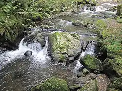 Waterfall near the Wolfsschlucht gorge | |
| Location | |
| Country | Germany |
| State | Rhineland-Palatinate |
| Districts | |
| Reference no. | DE: 26784 |
| Physical characteristics | |
| Source | |
| • location | On the heights of the Neroth woods in the county of Vulkaneifel |
| • coordinates | 50°12′37″N 6°45′36″E / 50.210182°N 6.75988°E |
| • elevation | ca. 584 m above sea level (NHN) |
| Mouth | |
• location | Discharges south of Manderscheid into the Lieser |
• coordinates | 50°03′48″N 6°48′51″E / 50.06322°N 6.814206°E |
• elevation | ca. 246 m above sea level (NHN) |
| Length | 23.879 km (14.838 mi) [1] |
| Basin size | 83.545 km2 (32.257 sq mi) [1] |
| Basin features | |
| Progression | Lieser→ Moselle→ Rhine→ North Sea |
| Landmarks | Villages: Neroth, Oberstadtfeld, Niederstadtfeld, Schutz |
| Tributaries | |
| • left | See table |
| • right | See table |
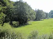 Valley of the Kleine Kyll south of its confluence with the Meerbach | |
The Little Kyll[2][3] German: Kleine Kyll, pronounced: "kill") is a 23.9-kilometre-long (14.9 mi) orographically right-hand tributary of the Lieser.
Geography
Course
The Little Kyll rises 2 kilometres (1.2 mi) northeast of Neroth on the heights of the Neroth woods in the county of Vulkaneifel in the German state of Rhineland-Palatinate. It flows in a southerly direction through the municipalities of Neroth, Oberstadtfeld, Niederstadtfeld and Schutz and empties into the Lieser south of Manderscheid, Bernkastel-Wittlich.
Tributaries
The tributaries of the Little Kyll include the following (in a downstream direction):[1]
| Name | GKZ | Length (km) | Direction | Confluene after km | Location |
|---|---|---|---|---|---|
| Enzenbach | 2678412 | 2.6 | right | 21.3 | Neroth |
| Kreuzbach | 26784132 | 0.8 | right | 20.5 | |
| Dehmbach | 1.0 | right | 19.7 | ||
| Bach vom Birkenberg (Winkelbach) | 2678414 | 1.5 | left | 18.2 | Oberstadtfeld |
| Risselbach | 1.3 | left | 16.6 | Niederstadtfeld | |
| Kälberbach | 2678416 | 3.9 | right | 16.2 | Niederstadtfeld |
| Kerlbach | 1.0 | left | 15.2 | Niederstadtfeld | |
| Walmerbach | 267842 | 7.2 | right | 11.9 | Schutz |
| Speicherbach | 267844 | 3.5 | right | 10.0 | |
| Meerbach | 267846 | 4.2 | right | 6.3 | Meerfeld |
| Ellbach | 26784712 | 2.0 | right | 4.7 | |
| Dombach | 1.0 | left | 2.6 | Manderscheid | |
| Horngraben | 2678472 | 2.5 | right | 1.9 | |
| Fischbach | 267848 | 6.1 | right | 0.8 |
Recreation
In the area between Oberstadtfeld and Bleckhausener Mühle/Meerfeld the cycleway Kosmosradweg runs parallel to the Kleine Kyll.
At the confluence with the Horngraben, south of Manderscheid is the gorge of Wolfsschlucht[4] as well as a waterfall.
See also
References
- 1 2 3 Geoexplorer of the Rhineland-Palatinate Water Authority (Wasserwirtschaftsverwaltung Rheinland-Pfalz)
- ↑ K. Baedeker (1870), The Rhine and Northern Germany: Handbook for Travellers, Coblenz: Baedeker, p. 116
- ↑ Charles B. MacDonald, United States Army in WWII - Europe - The Siegfried Line Campaign, p. xxx
- ↑ Wolfsschlucht und Kleine Kyll Archived 2013-10-10 at archive.today