Kishorenagar
Raj Kishorenagar | |
|---|---|
Town | |
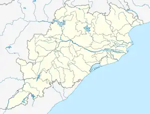 Kishorenagar Location In Odisha, India  Kishorenagar Kishorenagar (India) | |
| Coordinates: 20°57′08″N 84°28′14″E / 20.952281°N 84.470604°E | |
| country | |
| State | Odisha |
| District | Angul |
| Named for | Raja Kishore Chandra Deo Samant |
| Area | |
| • Total | 975.7 km2 (376.7 sq mi) |
| Elevation | 155 m (509 ft) |
| Population (2020) | |
| • Total | 131,740 |
| Languages | |
| • Official | Odia,English |
| Time zone | UTC+5:30 (IST) |
| Pin | 759126(Raj Kishoreagar)
759127(Kishoreganj) |
| Vehicle registration | OD-19(Angul)
OD-27(Boudh) Nearest RTO OD-15(Sambalpur) Nearest RTO |
| Nearest Towns | Angul, Athmallik, Sambalpur, Boudh |
| Literacy | 79.21% |
| Website | odisha |
Kishorenagar is a Town in Angul district Odisha state in India.it is Also called as Raj Kishorenagar.It is a Block under Athmallik Sub-Division.it is a Tahasil Area and Block Headquarter Office in there. It was 90 km from District Headquarter Angul.
This article is issued from Wikipedia. The text is licensed under Creative Commons - Attribution - Sharealike. Additional terms may apply for the media files.