Kirchberg bei Mattighofen | |
|---|---|
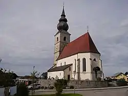 Kirchberg parish church | |
 Coat of arms | |
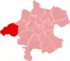
 Kirchberg bei Mattighofen Location within Austria | |
| Coordinates: 48°02′00″N 13°06′00″E / 48.03333°N 13.10000°E | |
| Country | Austria |
| State | Upper Austria |
| District | Braunau am Inn |
| Government | |
| • Mayor | Franz Zehentner |
| Area | |
| • Total | 15.77 km2 (6.09 sq mi) |
| Elevation | 560 m (1,840 ft) |
| Population (2018-01-01)[2] | |
| • Total | 1,175 |
| • Density | 75/km2 (190/sq mi) |
| Time zone | UTC+1 (CET) |
| • Summer (DST) | UTC+2 (CEST) |
| Postal code | 5232 |
| Area code | 07747 |
| Vehicle registration | BR |
| Website | www.oberoesterreich.at/ kirchberg.mattighofen |
Kirchberg bei Mattighofen is a municipality in the district of Braunau am Inn in the Austrian state of Upper Austria.
References
- ↑ "Dauersiedlungsraum der Gemeinden Politischen Bezirke und Bundesländer - Gebietsstand 1.1.2018". Statistics Austria. Retrieved 10 March 2019.
- ↑ "Einwohnerzahl 1.1.2018 nach Gemeinden mit Status, Gebietsstand 1.1.2018". Statistics Austria. Retrieved 9 March 2019.
Wikimedia Commons has media related to Kirchberg bei Mattighofen.
This article is issued from Wikipedia. The text is licensed under Creative Commons - Attribution - Sharealike. Additional terms may apply for the media files.