Kerkdriel | |
|---|---|
Town | |
 Flag  Coat of arms | |
 | |
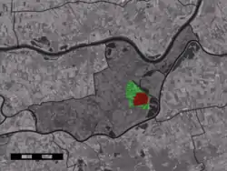 The town centre (red) and the statistical district (light green) of Kerkdriel in the municipality of Maasdriel. | |
| Coordinates: 51°46′N 5°20′E / 51.767°N 5.333°E | |
| Country | Netherlands |
| Province | Gelderland (north of the 'maas') |
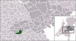
| Municipality | Maasdriel |
| Population (1 January 2019) | |
| • Total | 6,765 |
| Time zone | UTC+1 (CET) |
| • Summer (DST) | UTC+2 (CEST) |
| Postal code | 5331 |
| Dialing code | 0418 |
Kerkdriel is a town in the Dutch province of Gelderland. It is a part of the municipality of Maasdriel, and lies about 8 km north of 's-Hertogenbosch.
The town of Kerkdriel had 6,765 inhabitants, on 1 January 2019. The approximate built-up area of the town is 1.5 km², and contains 2,835 residences.[1] The statistical area "Kerkdriel", which includes peripheral parts of the village, as well as the surrounding countryside, has a population of around 10,210.[1]
Due to its positioning between two rivers (Meuse and Waal), a strong local linguistic accent developed during the post second-world-war period. Those who speak the "Driels" accent may be identified via the test phrase "Kees de Beer" (proper: Keas d'n Bear).
References
- 1 2 Statistics Netherlands (CBS), Kerncijfers wijken en buurten in Nederland 2019. (Statistics are for the continuous built-up area).
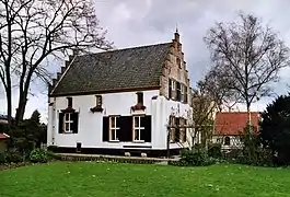
The historical building Teisterbant in Kerkdriel.
Wikimedia Commons has media related to Kerkdriel.
This article is issued from Wikipedia. The text is licensed under Creative Commons - Attribution - Sharealike. Additional terms may apply for the media files.