Kandreho (district) | |
|---|---|
 Kandreho (district) Location in Madagascar | |
| Coordinates: 17°29′S 46°06′E / 17.483°S 46.100°E | |
| Country | |
| Region | Betsiboka |
| District | Kandreho |
| Area | |
| • Total | 6,524 km2 (2,519 sq mi) |
| Population (2018)Census | |
| • Total | 25,964 |
| Time zone | UTC3 (EAT) |
| Postal code | 411 |
Kandreho is a district of Betsiboka in Madagascar.[2][3] It is situated at 144 km from Maevatanana.[4]
Communes
The district is further divided into seven municipalities:
Rivers
- Mahavavy Sud River, Kandreho River, Mahakamba, Namakia, Bekoratsaka River and the Menavava river.
See also
References
- ↑ MALNUTRITION ET L’EDUCATION - CAS DU DISTRICT DE KANDREHO
- ↑ REPOBLIKAN’I MADAGASIKARA:Tanindrazana – Fahafahana – Fandrosoana (PDF). MINISTERE DE L’AGRICULTURE, DE L’ELEVAGE ET DE LA PECHE. October 2007. pp. 42–44. Archived from the original (PDF) on 2018-06-12. Retrieved 2018-06-09.
- ↑ "Madagascar: Administrative Division". citypopulation. Retrieved 10 June 2018.
- ↑ Consommation des menages Commune de Behazomaty and Kandreho
Capital: Maevatanana | ||
| Kandreho (7) - 411 | 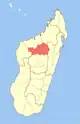 | |
| Maevatanana (20) - 412 | ||
| Tsaratanana (13) - 421 | ||
3 districts; 32 communes | ||
This article is issued from Wikipedia. The text is licensed under Creative Commons - Attribution - Sharealike. Additional terms may apply for the media files.