Kamysty | |
|---|---|
District | |
| Қамысты ауданы | |
 | |
| Country | |
| Region | Kostanay Region |
| Administrative center | Kamysty |
| Government | |
| • Akim | Yerlan Zhaulybayev[1] |
| Population (2013)[2] | |
| • Total | 14,482 |
| Time zone | UTC+6 (East) |
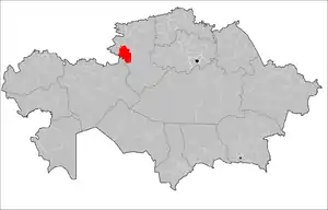
Kamysty (Kazakh: Қамысты ауданы, Qamysty audany) is a district of Kostanay Region in northern Kazakhstan. The administrative center of the district is the selo of Kamysty.[3] Population: 14,482 (2013 estimate);[2] 15,807 (2009 Census results);[4] 23,146 (1999 Census results).[4]
Geography
Kulykol, Teniz and Urkash lakes are located in the district, not far from the Kazakhstan–Russia border. [5]
References
- ↑ "Аким Камыстинского района назначен в Костанайской области". www.inform.kz. 2023-08-29.
- 1 2 "Население Республики Казахстан" (in Russian). Департамент социальной и демографической статистики. Retrieved 27 December 2013.
- ↑ "www.geonames.de Subdivisions of Kazakhstan in local languages". Archived from the original on 2016-03-03. Retrieved 2008-04-22.
- 1 2 "Население Республики Казахстан" [Population of the Republic of Kazakhstan] (in Russian). Департамент социальной и демографической статистики. Retrieved 8 December 2013.
- ↑ "M-41 Topographic Chart (in Russian)". Retrieved 9 August 2022.
Capital: Kostanay | ||
| Districts | 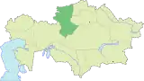 | |
| Major cities | ||
51°58′48″N 61°47′24″E / 51.98000°N 61.79000°E
This article is issued from Wikipedia. The text is licensed under Creative Commons - Attribution - Sharealike. Additional terms may apply for the media files.