Jiangnan
江南区 · Gyanghnanz Gih | |
|---|---|
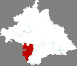 Location in Nanning | |
 Jiangnan Location in Guangxi | |
| Coordinates: 22°48′02″N 108°16′40″E / 22.8005°N 108.2779°E[1] | |
| Country | People's Republic of China |
| Autonomous region | Guangxi |
| Prefecture-level city | Nanning |
| Subdivisions | 4 subdistricts 4 towns |
| Area | |
| • Total | 1,298 km2 (501 sq mi) |
| Population (2020)[3] | |
| • Total | 542,100 |
| • Density | 420/km2 (1,100/sq mi) |
| Time zone | UTC+8 (China Standard) |
| Website | jnq |
Jiangnan District (simplified Chinese: 江南区; traditional Chinese: 江南區; pinyin: Jiāngnán Qū; Standard Zhuang: Gyanghnanz Gih) is one of seven districts of the prefecture-level city of Nanning, the capital of Guangxi Zhuang Autonomous Region, South China.
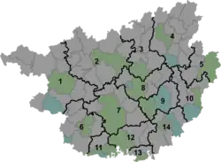
Administrative divisions
There are four subdistricts and four towns in the district:[4]
Subdistricts:
- Jiangnan Subdistrict (江南街道), Fujianyuan Subdistrict (福建园街道), Shajing Subdistrict (沙井街道), Nahong Subdistrict (那洪街道)
Towns:
References
- ↑ Google (2014-07-02). "Jiangnan Subdistrict Office" (Map). Google Maps. Google. Retrieved 2014-07-02.
- ↑ "Nanning City Land Use Plan (2006–20)"/"南宁市土地利用总体规划 (2006-2020年)".(in Chinese) Accessed 8 July 2014.
- ↑ "中国2010年人口普查分县资料" [Data by County for the 2010 Chinese Census] (in Chinese). 中国统计出版社. December 2012. ISBN 978-7-5037-6659-6.
- ↑ 2011年统计用区划代码和城乡划分代码:江南区 (in Chinese). National Bureau of Statistics of the People's Republic of China. Archived from the original on 2012-07-21. Retrieved 2013-01-03.
External links
This article is issued from Wikipedia. The text is licensed under Creative Commons - Attribution - Sharealike. Additional terms may apply for the media files.