J-Six Ranchettes, Arizona | |
|---|---|
 J-Six Ranchettes  J-Six Ranchettes | |
| Coordinates: 31°58′00″N 110°27′59″W / 31.96667°N 110.46639°W | |
| Country | United States |
| State | Arizona |
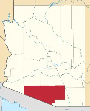
| County | Pima |
| Area | |
| • Total | 4.52 sq mi (11.72 km2) |
| • Land | 4.52 sq mi (11.72 km2) |
| • Water | 0.00 sq mi (0.00 km2) |
| Elevation | 4,160 ft (1,270 m) |
| Population (2020) | |
| • Total | 647 |
| • Density | 143.05/sq mi (55.23/km2) |
| Time zone | UTC-7 (MST) |
| ZIP Code | 85602 (Benson) |
| FIPS code | 04-36440 |
| GNIS feature ID | 2582841 |
J-Six Ranchettes is an unincorporated community and census-designated place (CDP) in Pima County, Arizona, United States. It is bordered to the east by Cochise County and is located along Interstate 10, 9 miles (14 km) west of Benson and 38 miles (61 km) southeast of Tucson. It was first listed as a CDP prior to the 2020 census.
Demographics
| Census | Pop. | Note | %± |
|---|---|---|---|
| 2020 | 647 | — | |
| U.S. Decennial Census[2] | |||
References
- ↑ "2020 U.S. Gazetteer Files". United States Census Bureau. Retrieved October 29, 2021.
- ↑ "Census of Population and Housing". Census.gov. Retrieved June 4, 2016.
This article is issued from Wikipedia. The text is licensed under Creative Commons - Attribution - Sharealike. Additional terms may apply for the media files.