Hirtzfelden | |
|---|---|
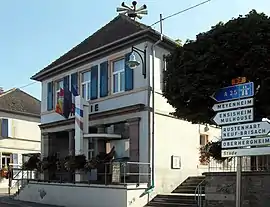 The town hall in Hirtzfelden | |
.svg.png.webp) Coat of arms | |
Location of Hirtzfelden | |
 Hirtzfelden 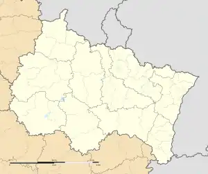 Hirtzfelden | |
| Coordinates: 47°54′45″N 7°26′46″E / 47.9125°N 7.4461°E | |
| Country | France |
| Region | Grand Est |
| Department | Haut-Rhin |
| Arrondissement | Colmar-Ribeauvillé |
| Canton | Ensisheim |
| Government | |
| • Mayor (2020–2026) | Stéphane Senez[1] |
| Area 1 | 22.1 km2 (8.5 sq mi) |
| Population | 1,317 |
| • Density | 60/km2 (150/sq mi) |
| Time zone | UTC+01:00 (CET) |
| • Summer (DST) | UTC+02:00 (CEST) |
| INSEE/Postal code | 68140 /68740 |
| Elevation | 206–217 m (676–712 ft) (avg. 210 m or 690 ft) |
| 1 French Land Register data, which excludes lakes, ponds, glaciers > 1 km2 (0.386 sq mi or 247 acres) and river estuaries. | |
Hirtzfelden (French pronunciation: [iʁtsfɛldən] ⓘ;[3] German: Hirzfelden; Alsatian: Hírzfàlde) is a commune in the Haut-Rhin department in Grand Est in north-eastern France.
See also
References
- ↑ "Répertoire national des élus: les maires". data.gouv.fr, Plateforme ouverte des données publiques françaises (in French). 2 December 2020.
- ↑ "Populations légales 2021". The National Institute of Statistics and Economic Studies. 28 December 2023.
- ↑ "Localisation et prononciation des noms de lieux d'Alsace commençant par H". elsasser.free.fr. Archived from the original on 2018-08-13. Retrieved 2019-02-01.
Wikimedia Commons has media related to Hirtzfelden.
This article is issued from Wikipedia. The text is licensed under Creative Commons - Attribution - Sharealike. Additional terms may apply for the media files.