Hano, Arizona | |
|---|---|
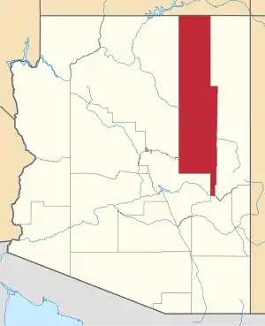
 Hano Location within the state of Arizona  Hano Hano (the United States) | |
| Coordinates: 35°50′13″N 110°23′32″W / 35.83694°N 110.39222°W | |
| Country | United States |
| State | Arizona |
| County | Navajo |
| Elevation | 6,211 ft (1,893 m) |
| Time zone | UTC-7 (Mountain (MST)) |
| • Summer (DST) | UTC-7 (MST) |
| Area code | 928 |
| FIPS code | 04-31040 |
| GNIS feature ID | 5545 |
Hano is a populated place situated in the First Mesa CDP in Navajo County, Arizona, United States, on the Hopi Reservation.[2]
It is located on the southern end of First Mesa, approximately 0.7 miles (1.1 km) west of Polacca. It has an estimated elevation of 6,211 feet (1,893 m) above sea level.[1]
History
The village was settled by the Hopi-Tewa, a band of Tewa people, in the early 17th century on First Mesa.
Name
The village has been known by a plethora of names, including Ha-no-me, Hanoki, Janogualpa, Na-ca-ci-kin, Tanoquevi, Tanus, Te-e-wun-na, and Tewa. In 1915, the Board on Geographic Names officially named it Tegua, before changing their decision in 1989 to the current Hano. Hano is a Hopi term meaning "eastern people".
References
- 1 2 "Feature Detail Report for: Hano". Geographic Names Information System. United States Geological Survey, United States Department of the Interior.
- ↑ "Hano (in Navajo County, AZ) Populated Place Profile". AZ Hometown Locator. Retrieved November 23, 2016.
This article is issued from Wikipedia. The text is licensed under Creative Commons - Attribution - Sharealike. Additional terms may apply for the media files.