Hannersdorf | |
|---|---|
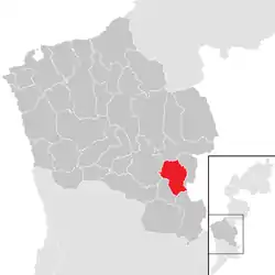 Location within Oberwart district | |
 Hannersdorf Location within Austria | |
| Coordinates: 47°14′N 16°23′E / 47.233°N 16.383°E | |
| Country | Austria |
| State | Burgenland |
| District | Oberwart |
| Government | |
| • Mayor | Erich Werderits |
| Area | |
| • Total | 17.11 km2 (6.61 sq mi) |
| Elevation | 268 m (879 ft) |
| Population (2018-01-01)[2] | |
| • Total | 758 |
| • Density | 44/km2 (110/sq mi) |
| Time zone | UTC+1 (CET) |
| • Summer (DST) | UTC+2 (CEST) |
| Postal code | 7473 |
| Website | www.hannersdorf.at |
Hannersdorf (Hungarian: Sámfalva) is a municipality in Burgenland in the district of Oberwart in Austria.
Geography
Parts of the municipality are Hannersdorf, Burg, and Woppendorf.
Population
| Year | Pop. | ±% |
|---|---|---|
| 1869 | 1,487 | — |
| 1880 | 1,543 | +3.8% |
| 1890 | 1,671 | +8.3% |
| 1900 | 1,773 | +6.1% |
| 1910 | 1,573 | −11.3% |
| 1923 | 1,406 | −10.6% |
| 1934 | 1,346 | −4.3% |
| 1939 | 1,281 | −4.8% |
| 1951 | 1,275 | −0.5% |
| 1961 | 1,175 | −7.8% |
| 1971 | 1,042 | −11.3% |
| 1981 | 1,002 | −3.8% |
| 1991 | 864 | −13.8% |
| 2001 | 848 | −1.9% |
| 2011 | 794 | −6.4% |
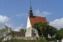
Roman Catholic parish church in Hannersdorf
Politics
Of the 15 positions on the municipal council, the SPÖ has 8, and the ÖVP 7.
References
- ↑ "Dauersiedlungsraum der Gemeinden Politischen Bezirke und Bundesländer - Gebietsstand 1.1.2018". Statistics Austria. Retrieved 10 March 2019.
- ↑ "Einwohnerzahl 1.1.2018 nach Gemeinden mit Status, Gebietsstand 1.1.2018". Statistics Austria. Retrieved 9 March 2019.
External links
Wikimedia Commons has media related to Hannersdorf.
This article is issued from Wikipedia. The text is licensed under Creative Commons - Attribution - Sharealike. Additional terms may apply for the media files.