| Han River | |
|---|---|
 | |
| Native name | 旱溪 (Chinese) |
| Location | |
| Country | Taiwan |
| City | Taichung |
| Physical characteristics | |
| Source | Gonglaoping |
| • location | Fengyuan District |
| • coordinates | 24°15′40″N 120°45′59″E / 24.2610°N 120.7663°E |
| Mouth | Dali River |
• location | Dali District |
• coordinates | 24°07′25″N 120°42′10″E / 24.1235°N 120.7028°E |
| Length | 33.5 km |
| Basin features | |
| River system | Dadu River |
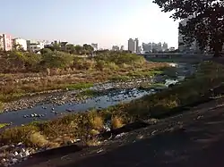
The Han River (Chinese: 旱溪; pinyin: Hànxī, lit. "dry creek") is a river located in Taichung, Taiwan. The river flows southwards from Gonglaoping in Fengyuan District until it joins the Dali River near Provincial Highway 74 in Dali District.[1]
Even though the river is wide, it's relatively low discharge means that the river runs dry for most of the year, hence the name.[2] A bike path known as the "Han River Bike Trail" (旱溪自行車道) runs alongside the river between Fengyuan and Dali.[3]
References
- ↑ "水利地理2D/3D整合圖台". Water Resources Agency (in Chinese (Taiwan)). Retrieved February 28, 2020.
- ↑ "旱溪". East District Office (in Chinese (Taiwan)). December 31, 2019. Retrieved February 28, 2020.
- ↑ "旱溪自行車道". Taichung Travel Net (in Chinese (Taiwan)). Taichung City Government. November 18, 2018. Retrieved February 28, 2020.
This article is issued from Wikipedia. The text is licensed under Creative Commons - Attribution - Sharealike. Additional terms may apply for the media files.