Bydel Høle | |
|---|---|
 Coat of arms | |
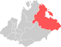 Location within Sandnes municipality | |
| Coordinates: 58°53′44″N 06°00′33″E / 58.89556°N 6.00917°E | |
| Country | Norway |
| Region | Western Norway |
| County | Rogaland |
| District | Jæren |
| City | Sandnes |
| Area | |
| • Total | 101.4 km2 (39.2 sq mi) |
| Elevation | 22 m (72 ft) |
| Population (2016)[2] | |
| • Total | 1,042 |
| • Density | 10/km2 (27/sq mi) |
| Time zone | UTC+01:00 (CET) |
| • Summer (DST) | UTC+02:00 (CEST) |
| Post Code | 4308 Sandnes |
Høle is a previous borough and a village in the eastern part of Sandnes municipality in Rogaland county, Norway, located along the Høgsfjorden. The area was historically a part of the municipality of Høle. Høle Church and Høle School are both located in the village.
The 0.36-square-kilometre (89-acre) village has a population (2015) of 427, giving the village a population density of 1,186 inhabitants per square kilometre (3,070/sq mi).[3] The borough of Høle is the least populous (and most rural) borough in the city of Sandnes with 1,042 inhabitants.[2] The 101.4-square-kilometre (39.2 sq mi) borough is located in the eastern part of the municipality.
References
- ↑ "Høle, Sandnes (Rogaland)" (in Norwegian). yr.no. Retrieved 2016-03-29.
- 1 2 "Sandnes i tall" (in Norwegian). Sandnes Municipality. Archived from the original on 25 November 2014. Retrieved 3 June 2011.
- ↑ Statistisk sentralbyrå (1 January 2015). "Urban settlements. Population and area, by municipality".
Boroughs of Sandnes | |||
|---|---|---|---|
| |||
This article is issued from Wikipedia. The text is licensed under Creative Commons - Attribution - Sharealike. Additional terms may apply for the media files.