| Gebel al-Ain | |
|---|---|
 | |
| Highest point | |
| Elevation | 570 m (1,870 ft) |
| Coordinates | 16°35′00″N 29°15′12″E / 16.58333°N 29.25333°E |
| Geography | |
| Country | Sudan |
| Region | Northern state/Northern Kurdufan |
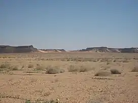
Gebel al-Ain is a plateau in Sudan at the border between the Northern state and North Kurdufan.
The Gebel al-Ain area is more fertile than the surrounding dry savannah, making it a popular grazing ground for the Kababish-nomads dwelling around it.
Around the Gebel al-Ain many archaeological sites are situated, mostly graveyards of the post-Meroitic and medieval Christian period. The most prominent archaeological sites are a ruined monastery in the west of the mountain – the south-westernmost outpost of the Makurian state known so far[1] – and a settlement of round huts with a surrounding wall close to Bir al-Ain southwest of the main top of the mountain.[2]
References
This article is issued from Wikipedia. The text is licensed under Creative Commons - Attribution - Sharealike. Additional terms may apply for the media files.