| Gable Mountain | |
|---|---|
 Northwest aspect | |
| Highest point | |
| Elevation | 9,267 ft (2,825 m)[1] NAVD 88 |
| Prominence | 1,902 ft (580 m)[1] |
| Parent peak | Mount Wilbur |
| Listing | Mountains in Glacier County, Montana |
| Coordinates | 48°54′22″N 113°40′25″W / 48.90611°N 113.67361°W[2] |
| Geography | |
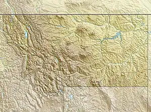 Gable Mountain Location in Montana  Gable Mountain Location in the United States | |
| Location | Glacier County, Montana, U.S. |
| Parent range | Lewis Range |
| Topo map | USGS Gable Mountain, MT |
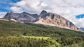
Gable Mountain (9,262 feet (2,823 m)) is located in the Lewis Range, Glacier National Park in the U.S. state of Montana.[3] Gable Mountain is in the northeastern section of Glacier National Park, approximately 3 miles (4.8 km) southwest of the prominent Chief Mountain.
.jpg.webp)
Gable Mountain to right with Chief Mountain to the left
See also
References
- 1 2 "Gable Mountain, Montana". Peakbagger.com. Retrieved June 12, 2018.
- ↑ "Gable Mountain". Geographic Names Information System. United States Geological Survey, United States Department of the Interior. Retrieved June 12, 2018.
- ↑ Gable Mountain, MT (Map). TopoQwest (United States Geological Survey Maps). Retrieved June 12, 2018.
This article is issued from Wikipedia. The text is licensed under Creative Commons - Attribution - Sharealike. Additional terms may apply for the media files.