| Fruid Water | |
|---|---|
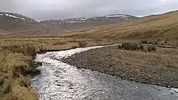 Fruid Water above Fruid Reservoir | |
| Location | |
| Country | United Kingdom |
| Part | Scotland, England |
| Physical characteristics | |
| Mouth | Tweed |
• coordinates | 55°28′53″N 3°26′53″W / 55.4815°N 3.448°W |
| Basin size | 23.7 km2 |
| Depth | |
| • average | 0.66 cubic metres |
| Discharge | |
| • location | Fruid Reservoir |
Fruid Water is a river in the Scottish Borders area of Scotland. The valley it occupies has been dammed to form the Fruid Reservoir. The river is a tributary of the Tweed, with a confluence about 2 km upstream of Tweedsmuir. The river has a catchment area of 23.7 km2, and a mean flow rate of 0.66 cubic metres per second leaving the reservoir.[1]
References
- ↑ "Section 2: The catchments of the Tweed and the Eye" (PDF). The Tweed Foundation. Retrieved 1 January 2016.
This article is issued from Wikipedia. The text is licensed under Creative Commons - Attribution - Sharealike. Additional terms may apply for the media files.