Fittstown, Oklahoma | |
|---|---|
 Fittstown, Oklahoma  Fittstown, Oklahoma | |
| Coordinates: 34°36′33″N 96°38′26″W / 34.60917°N 96.64056°W | |
| Country | United States |
| State | Oklahoma |
| County | Pontotoc |
| Area | |
| • Total | 1.07 sq mi (2.78 km2) |
| • Land | 1.07 sq mi (2.78 km2) |
| • Water | 0.00 sq mi (0.00 km2) |
| Elevation | 856 ft (261 m) |
| Population (2020) | |
| • Total | 78 |
| • Density | 72.76/sq mi (28.09/km2) |
| Time zone | UTC-6 (Central (CST)) |
| • Summer (DST) | UTC-5 (CDT) |
| ZIP code | 74842 |
| Area code | 580 |
| GNIS feature ID | 2805317[2] |
Fittstown is an unincorporated community in Pontotoc County, Oklahoma, United States. Fittstown is located on U.S. Route 377, 11 miles (18 km) south-southeast of Ada. Fittstown has a post office with ZIP code 74842.[3]
Demographics
| Census | Pop. | Note | %± |
|---|---|---|---|
| 2020 | 78 | — | |
| U.S. Decennial Census[4] | |||
References
- ↑ "ArcGIS REST Services Directory". United States Census Bureau. Retrieved September 20, 2022.
- 1 2 U.S. Geological Survey Geographic Names Information System: Fittstown, Oklahoma
- ↑ ZIP Code Lookup
- ↑ "Census of Population and Housing". Census.gov. Retrieved June 4, 2016.
Municipalities and communities of Pontotoc County, Oklahoma, United States | ||
|---|---|---|
| City | 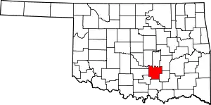 Pontotoc County map | |
| Towns | ||
| CDPs | ||
| Other communities | ||
| Indian reservations | ||
| Footnotes | ‡This populated place also has portions in an adjacent county or counties | |
This article is issued from Wikipedia. The text is licensed under Creative Commons - Attribution - Sharealike. Additional terms may apply for the media files.