| Egiin Gol | |
|---|---|
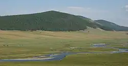 Egiin Gol some kilometers south of Khatgal | |
| Native name | Эгийн гол (Mongolian) |
| Location | |
| Country | Mongolia |
| Aimags | Khövsgöl, Bulgan |
| Major city | Khatgal |
| Physical characteristics | |
| Source | Lake Khövsgöl |
| • location | near Khatgal |
| • coordinates | 50°25′10″N 100°09′10″E / 50.41944°N 100.15278°E |
| • elevation | 1,645 m (5,397 ft) |
| Mouth | Selenga |
• coordinates | 49°23′15″N 103°37′30″E / 49.38750°N 103.62500°E |
| Length | 475 km (295 mi) |
| Basin size | 49,100 km2 (19,000 sq mi) |
| Basin features | |
| Progression | Selenga→ Lake Baikal→ Angara→ Yenisey→ Kara Sea |
| Tributaries | |
| • left | Üür River, Tarvagatai River |
The Egiin Gol (Mongolian: Эгийн гол) is a river in the Khövsgöl and Bulgan aimags in northern Mongolia. It is the only outflow of Lake Khövsgöl and a left tributary of the Selenge river. It is 475 kilometres (295 mi) long, and has a drainage basin of 49,100 square kilometres (19,000 sq mi).[1] Wooden bridges exist near Khatgal and in Tünel sum, and a concrete bridge has been built in Erdenebulgan. In Bulgan aimag there is a bridge between Teshig and Khutag-Öndör sums.
Since the early 1990s there have been efforts to build a hydroelectric dam on this river. These attempts, however, have been opposed by several academic communities: archaeology because of the rich and not yet fully explored archaeological sites in area; geology because the area may have earthquakes. A dam would also displace parts of the local population as it floods some pastures and homesteads.
See also
References