Eals Bridge | |
|---|---|
 Eals Bridge | |
| Coordinates | 54°53′30″N 2°29′53″W / 54.8917°N 2.4981°W |
| OS grid reference | NY682553 |
| Carries | Motor vehicles |
| Crosses | River South Tyne |
| Locale | Northumberland |
| Heritage status | Grade II listed[1] |
| Preceded by | Parson Shields Farm Bridge |
| Followed by | Eals Footbridge |
| Characteristics | |
| Material | Stone |
| No. of spans | 2 |
| Piers in water | 1 |
| No. of lanes | Single-track road |
| History | |
| Construction end | 1733 |
| Opened | 1733 |
| Location | |
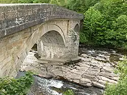
Eals Bridge is a stone bridge across the River South Tyne near Knarsdale in Northumberland.
History
This structure has two stone arches and was completed in 1733 but seriously damaged by flooding in 1829.[2] Widened in 1973, it carries road traffic and is a Grade II listed structure.[1]
References
- 1 2 Historic England. "Eals Bridge (Grade II) (1155442)". National Heritage List for England. Retrieved 5 September 2018.
- ↑ "South Tyne - Eals Bridge". Bridges on the Tyne. Retrieved 22 January 2017.
This article is issued from Wikipedia. The text is licensed under Creative Commons - Attribution - Sharealike. Additional terms may apply for the media files.