| Dospat (Доспат, Δεσπάτης) | |
|---|---|
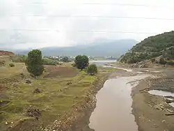 Dospat River at its mouth | |
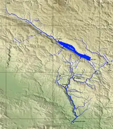 Dospat River system | |
| Location | |
| Countries | Bulgaria and Greece |
| Physical characteristics | |
| Source | |
| • location | Rhodope Mountains |
| • elevation | 1,610 m (5,280 ft) |
| Mouth | |
• location | Mesta/Nestos |
• coordinates | 41°23′25″N 24°5′15″E / 41.39028°N 24.08750°E |
• elevation | 366 m (1,201 ft) |
| Length | 110 km (68 mi) |
| Basin size | 633.5 km2 (244.6 sq mi) |
| Basin features | |
| Progression | Nestos→ Aegean Sea |
| Tributaries | |
| • left | Sarnena |
| • right | Kochan, Osina |
The Dospat (Bulgarian: Доспат; Greek: Δεσπάτης, Despatis) is a river in the Western Rhodope Mountains, the most important tributary of the Mesta.
It takes its source from Bulgaria, from the 1643-metre-high Rozov vrah ("Rose Peak") and flows southeast until Dospat Dam, after which it makes a turn southwest to continue generally to the south and flow into the Mesta as a left tributary near the village Mikrokleisoura on Greek territory just south of the Greek-Bulgarian border.
The Dospat has a drainage basin of 633.5 km2. Its length is 110 km, of which 79 in Bulgaria[1] and 21 in Greece. For a small distance of 3 km it forms the Greek–Bulgarian border.
Wikimedia Commons has media related to Dospat River.
References
This article is issued from Wikipedia. The text is licensed under Creative Commons - Attribution - Sharealike. Additional terms may apply for the media files.