Dagda | |
|---|---|
Town | |
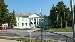 Town hall in Dagda | |
 Flag  Coat of arms | |
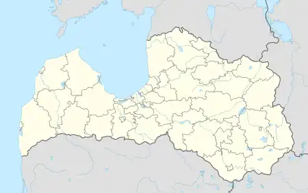 Dagda Location in Latvia | |
| Coordinates: 56°5′N 27°32′E / 56.083°N 27.533°E | |
| Country | |
| Municipality | Krāslava Municipality |
| Town rights | 1992 |
| Government | |
| • Mayor | Viktors Stikuts |
| • City council | 9 members |
| Area | |
| • Total | 2.92 km2 (1.13 sq mi) |
| • Land | 2.86 km2 (1.10 sq mi) |
| • Water | 0.06 km2 (0.02 sq mi) |
| Population (2023)[2] | |
| • Total | 1,816 |
| • Density | 620/km2 (1,600/sq mi) |
| Time zone | UTC+2 (EET) |
| • Summer (DST) | UTC+3 (EEST) |
| Postal code | LV-5674 |
| Calling code | +371 656 |
| Climate | Dfb |
| Website | www |
Dagda (ⓘ) is a town in Dagda Parish, Krāslava Municipality in the Latgale region of Latvia, near the country's border with Belarus. It is the administrative center of Dagda Parish.
Climate
Dagda has a humid continental climate (Köppen Dfb). In March 1972, the deepest ground frost in Latvia was registered in Dagda - 150 cm (59 in).[3]
| Climate data for Dagda, Latvia (1991-2020 normals, extremes 1956-present) | |||||||||||||
|---|---|---|---|---|---|---|---|---|---|---|---|---|---|
| Month | Jan | Feb | Mar | Apr | May | Jun | Jul | Aug | Sep | Oct | Nov | Dec | Year |
| Record high °C (°F) | 10.3 (50.5) |
11.4 (52.5) |
17.8 (64.0) |
26.0 (78.8) |
29.7 (85.5) |
31.3 (88.3) |
34.0 (93.2) |
34.7 (94.5) |
29.4 (84.9) |
23.0 (73.4) |
15.0 (59.0) |
10.0 (50.0) |
34.7 (94.5) |
| Mean daily maximum °C (°F) | −2.3 (27.9) |
−1.6 (29.1) |
3.4 (38.1) |
11.6 (52.9) |
17.7 (63.9) |
21.0 (69.8) |
23.3 (73.9) |
22.1 (71.8) |
16.5 (61.7) |
9.5 (49.1) |
3.0 (37.4) |
−0.8 (30.6) |
10.3 (50.5) |
| Daily mean °C (°F) | −4.8 (23.4) |
−4.7 (23.5) |
−0.5 (31.1) |
6.4 (43.5) |
12.0 (53.6) |
15.5 (59.9) |
17.8 (64.0) |
16.6 (61.9) |
11.7 (53.1) |
5.9 (42.6) |
0.7 (33.3) |
−2.9 (26.8) |
6.1 (43.1) |
| Mean daily minimum °C (°F) | −7.5 (18.5) |
−8.1 (17.4) |
−4.5 (23.9) |
1.3 (34.3) |
6.3 (43.3) |
10.1 (50.2) |
12.7 (54.9) |
11.5 (52.7) |
7.2 (45.0) |
2.6 (36.7) |
−1.7 (28.9) |
−5.3 (22.5) |
2.1 (35.7) |
| Record low °C (°F) | −36.1 (−33.0) |
−37.6 (−35.7) |
−32.0 (−25.6) |
−16.2 (2.8) |
−3.2 (26.2) |
0.0 (32.0) |
4.3 (39.7) |
1.0 (33.8) |
−3.8 (25.2) |
−11.0 (12.2) |
−23.3 (−9.9) |
−35.8 (−32.4) |
−37.6 (−35.7) |
| Average precipitation mm (inches) | 48.5 (1.91) |
42.7 (1.68) |
37.9 (1.49) |
37.1 (1.46) |
61.0 (2.40) |
78.3 (3.08) |
73.2 (2.88) |
70.7 (2.78) |
55.8 (2.20) |
62.9 (2.48) |
54.9 (2.16) |
47.6 (1.87) |
670.6 (26.39) |
| Source: LVĢMC[4][5] | |||||||||||||
See also
References
- ↑ "Reģionu, novadu, pilsētu un pagastu kopējā un sauszemes platība gada sākumā". Central Statistical Bureau of Latvia. Retrieved 18 January 2023.
- ↑ "Iedzīvotāju skaits pēc tautības reģionos, pilsētās, novados, pagastos, apkaimēs un blīvi apdzīvotās teritorijās gada sākumā (pēc administratīvi teritoriālās reformas 2021. gadā) 2021 - 2022". Central Statistical Bureau of Latvia. Retrieved 2 October 2023.
- ↑ Latvijas pagasti. Enciklopēdija. Rīga: A/S Preses nams. 2001–2002. ISBN 9984-00-412-0.
- ↑ "Klimatisko normu dati". Latvian Environment, Geology and Meteorology Centre. Retrieved March 21, 2023.
- ↑ "Gaisa temperatūras rekordi". Latvian Environment, Geology and Meteorology Centre. Retrieved March 21, 2023.
This article is issued from Wikipedia. The text is licensed under Creative Commons - Attribution - Sharealike. Additional terms may apply for the media files.