Chloride, Missouri | |
|---|---|
 Chloride  Chloride | |
| Coordinates: 37°27′38″N 90°41′13″W / 37.46056°N 90.68694°W | |
| Country | United States |
| State | Missouri |
| County | Iron |
| Elevation | 801 ft (244 m) |
| Time zone | UTC-6 (Central (CST)) |
| • Summer (DST) | UTC-5 (CDT) |
| Area code | 573 |
| GNIS feature ID | 749349[1] |
Chloride is an unincorporated community in Iron County, in the U.S. state of Missouri.[1] Chloride is located on Big Creek along Missouri Route 49. The community is approximately 1.5 miles south of the lead smelter at Glover.[2]
History
A post office called Chloride was established in 1904, and remained in operation until 1953.[3] The community's name is a transfer from Chloride, Arizona, the onetime home of an early settler.[4]
References
- 1 2 3 U.S. Geological Survey Geographic Names Information System: Chloride, Missouri
- ↑ Glover, Missouri, 7.5 Minute Topographic Quadrangle, USGS, 2000 (2003 rev.)
- ↑ "Post Offices". Jim Forte Postal History. Archived from the original on October 12, 2016. Retrieved October 11, 2016.
- ↑ "Iron County Place Names, 1928–1945 (archived)". The State Historical Society of Missouri. Archived from the original on June 24, 2016. Retrieved October 11, 2016.
{{cite web}}: CS1 maint: bot: original URL status unknown (link)
Municipalities and communities of Iron County, Missouri, United States | ||
|---|---|---|
| Cities | 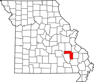 Map of Missouri highlighting Iron County | |
| Village | ||
| Townships | ||
| Unincorporated communities | ||
| Ghost towns | ||
| Footnotes | ‡This populated place also has portions in an adjacent county or counties | |
This article is issued from Wikipedia. The text is licensed under Creative Commons - Attribution - Sharealike. Additional terms may apply for the media files.