Cherryvale, Indiana | |
|---|---|
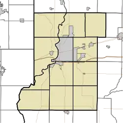 Cherryvale Cherryvale, as seen in a map of Vigo County | |
| Coordinates: 39°27′48″N 87°14′22″W / 39.46333°N 87.23944°W | |
| Country | United States |
| State | Indiana |
| County | Vigo, Clay |
| Township | Lost Creek, Posey |
| Elevation | 584 ft (178 m) |
| Time zone | UTC-5 (Eastern (EST)) |
| • Summer (DST) | UTC-4 (EDT) |
| ZIP code | 47834 |
| Area code(s) | 812, 930 |
| GNIS feature ID | 432447 [1] |
Cherryvale is an unincorporated community in Vigo and Clay counties, in the U.S. state of Indiana.[1]
It is part of the Terre Haute metropolitan area.
History
Cherryvale was not formally laid out or platted.[2] A post office was established at Cherryvale in 1899, and remained in operation until it was discontinued in 1904.[3]
Geography
Cherryvale is located in western Clay County adjacent to the Vigo-Clay county line approximately one mile north of I-70.[4]
References
- 1 2 3 U.S. Geological Survey Geographic Names Information System: Cherryvale, Indiana
- ↑ Baker, Ronald L. (October 1995). From Needmore to Prosperity: Hoosier Place Names in Folklore and History. Indiana University Press. p. 93. ISBN 978-0-253-32866-3.
...this village, located on the Clay-Vigo county line, was never laid out.
- ↑ "Clay County". Jim Forte Postal History. Retrieved August 7, 2017.
- ↑ Staunton, IN, 7.5 Minute Topographic Quadrangle, USGS, 1958 (1990 rev.)
Municipalities and communities of Clay County, Indiana, United States | ||
|---|---|---|
| City | Map of Indiana highlighting Clay County | |
| Towns | ||
| Townships | ||
| CDPs | ||
| Other communities |
| |
| Ghost towns | ||
| Footnotes | ‡This populated place also has portions in an adjacent county or counties | |
Municipalities and communities of Vigo County, Indiana, United States | ||
|---|---|---|
| City | Map of Indiana highlighting Vigo County | |
| Towns | ||
| Townships | ||
| CDPs | ||
| Other communities |
| |
| Footnotes | ‡This populated place also has portions in an adjacent county or counties | |
This article is issued from Wikipedia. The text is licensed under Creative Commons - Attribution - Sharealike. Additional terms may apply for the media files.