Bursard | |
|---|---|
 | |
Location of Bursard | |
 Bursard 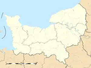 Bursard | |
| Coordinates: 48°32′28″N 0°12′43″E / 48.5411°N 0.2119°E | |
| Country | France |
| Region | Normandy |
| Department | Orne |
| Arrondissement | Alençon |
| Canton | Écouves |
| Government | |
| • Mayor (2020–2026) | Éric Lecarvennec[1] |
| Area 1 | 10.55 km2 (4.07 sq mi) |
| Population | 202 |
| • Density | 19/km2 (50/sq mi) |
| Time zone | UTC+01:00 (CET) |
| • Summer (DST) | UTC+02:00 (CEST) |
| INSEE/Postal code | 61068 /61500 |
| Elevation | 144–207 m (472–679 ft) (avg. 160 m or 520 ft) |
| 1 French Land Register data, which excludes lakes, ponds, glaciers > 1 km2 (0.386 sq mi or 247 acres) and river estuaries. | |
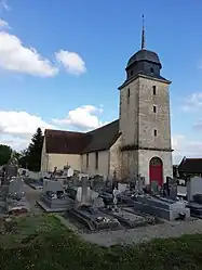
Bursard is a commune in the Orne department in northwestern France.
Population
| Year | Pop. | ±% p.a. |
|---|---|---|
| 1968 | 211 | — |
| 1975 | 193 | −1.27% |
| 1982 | 172 | −1.63% |
| 1990 | 194 | +1.52% |
| 1999 | 196 | +0.11% |
| 2009 | 197 | +0.05% |
| 2014 | 204 | +0.70% |
| 2020 | 203 | −0.08% |
| Source: INSEE[3] | ||
See also
References
- ↑ "Répertoire national des élus: les maires". data.gouv.fr, Plateforme ouverte des données publiques françaises (in French). 2 December 2020.
- ↑ "Populations légales 2021". The National Institute of Statistics and Economic Studies. 28 December 2023.
- ↑ Population en historique depuis 1968, INSEE
Wikimedia Commons has media related to Bursard.
This article is issued from Wikipedia. The text is licensed under Creative Commons - Attribution - Sharealike. Additional terms may apply for the media files.