Bouy-sur-Orvin | |
|---|---|
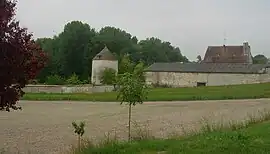 Chateau | |
Location of Bouy-sur-Orvin | |
 Bouy-sur-Orvin 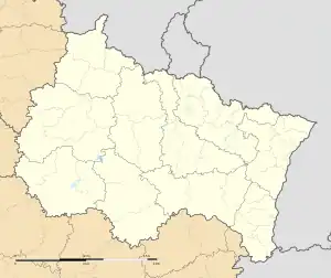 Bouy-sur-Orvin | |
| Coordinates: 48°24′48″N 3°29′57″E / 48.4133°N 3.4992°E | |
| Country | France |
| Region | Grand Est |
| Department | Aube |
| Arrondissement | Nogent-sur-Seine |
| Canton | Nogent-sur-Seine |
| Intercommunality | Nogentais |
| Government | |
| • Mayor (2020–2026) | Michel Jerome[1] |
| Area 1 | 6.7 km2 (2.6 sq mi) |
| Population | 53 |
| • Density | 7.9/km2 (20/sq mi) |
| Time zone | UTC+01:00 (CET) |
| • Summer (DST) | UTC+02:00 (CEST) |
| INSEE/Postal code | 10057 /10400 |
| 1 French Land Register data, which excludes lakes, ponds, glaciers > 1 km2 (0.386 sq mi or 247 acres) and river estuaries. | |
Bouy-sur-Orvin (French pronunciation: [bwi syʁ ɔʁvɛ̃]) is a commune in the Aube department in north-central France.
Population
| Year | Pop. | ±% |
|---|---|---|
| 1962 | 80 | — |
| 1968 | 92 | +15.0% |
| 1975 | 73 | −20.7% |
| 1982 | 64 | −12.3% |
| 1990 | 56 | −12.5% |
| 1999 | 56 | +0.0% |
| 2008 | 62 | +10.7% |
See also
References
- ↑ "Répertoire national des élus: les maires". data.gouv.fr, Plateforme ouverte des données publiques françaises (in French). 2 December 2020.
- ↑ "Populations légales 2021". The National Institute of Statistics and Economic Studies. 28 December 2023.
Wikimedia Commons has media related to Bouy-sur-Orvin.
This article is issued from Wikipedia. The text is licensed under Creative Commons - Attribution - Sharealike. Additional terms may apply for the media files.