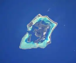
 The Island of Bora Bora in the center of the Bora Bora Group. | |
| Geography | |
|---|---|
| Location | Pacific Ocean |
| Archipelago | Society Islands |
| Area | 19.91 km2 (7.69 sq mi) |
| Highest elevation | 727 m (2385 ft) |
| Highest point | Mount Otemanu |
| Administration | |
France | |
| Overseas collectivity | French Polynesia |
| Administrative subdivision | Leeward Islands |
| Commune | Bora Bora Commune |
| Largest settlement | Vaitape (pop. 4,927 inhabitants) |
| Demographics | |
| Population | 9455 (2016) |
| Pop. density | 475/km2 (1230/sq mi) |
Bora Bora Island is a 19.91 km2 (8 sq mi) island in the Bora Bora Islands Group, within the Society Islands of French Polynesia. It is the main island of the commune of the same name.[1] Together with its surrounding islands of Tapu, Ahuna, Tevairoa, Tane, Mute, Tufari, Tehotu, Pitiaau, Sofitel, Toopua, and Toopuaiti, it forms the group of Bora Bora.[2]
See also
References
External links
This article is issued from Wikipedia. The text is licensed under Creative Commons - Attribution - Sharealike. Additional terms may apply for the media files.