Bolešov | |
|---|---|
Municipality | |
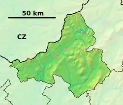 Bolešov Location of Bolešov in the Trenčín Region  Bolešov Bolešov (Slovakia) | |
| Coordinates: 48°59′N 18°09′E / 48.983°N 18.150°E | |
| Country | Slovakia |
| Region | Trenčín |
| District | Ilava |
| First mentioned | 1331 |
| Area | |
| • Total | 14.951 km2 (5.773 sq mi) |
| Elevation | 241 m (791 ft) |
| Population | |
| • Total | 1,465 |
| • Density | 98/km2 (250/sq mi) |
| Postal code | 018 53 |
| Area code | 421-42 |
| Car plate | IL |
| Website | www.bolesov.eu |
Bolešov (Slovak pronunciation: [ˈbɔleʂɔw]; Hungarian: Bolesó) is a village and municipality in Ilava District in the Trenčín Region of north-western Slovakia.
History
In historical records the village was first mentioned in 1331.
Geography
The municipality lies at an altitude of 241 metres and covers an area of 14.951 km². It has a population of about 1465 people.
Genealogical resources
The records for genealogical research are available at the state archive "Statny Archiv in Bytca, Slovakia"
- Roman Catholic church records (births/marriages/deaths): 1700-1896 (parish A)
See also
External links
- Official page
- https://web.archive.org/web/20071116010355/http://www.statistics.sk/mosmis/eng/run.html
- Surnames of living people in Bolesov
Municipalities of Ilava District | ||
|---|---|---|
This article is issued from Wikipedia. The text is licensed under Creative Commons - Attribution - Sharealike. Additional terms may apply for the media files.