Blue Ball, Delaware | |
|---|---|
 Blue Ball  Blue Ball | |
| Coordinates: 39°46′38″N 75°32′41″W / 39.77722°N 75.54472°W | |
| Country | United States |
| State | Delaware |
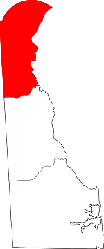
| County | New Castle |
| Elevation | 295 ft (90 m) |
| Time zone | UTC-5 (Eastern (EST)) |
| • Summer (DST) | UTC-4 (EDT) |
| Area code | 302 |
| GNIS feature ID | 216043[1] |
Blue Ball is an unincorporated community in New Castle County, Delaware, United States.[1][2][3] Blue Ball is located at the junction of U.S. Route 202, Delaware Route 141, and Delaware Route 261, north of Wilmington.[4] It takes it name from eponymous tavern.[5][6][7] The area was originally developed by the Weldin family.[8] Many of the structures in the area has since been demolished.[9]
See also
References
- 1 2 "Blue Ball". Geographic Names Information System. United States Geological Survey, United States Department of the Interior.
- ↑ "These 12 Towns In Delaware Have The Strangest Names You'll Ever See". OnlyInYourState. March 23, 2020.
- ↑ Federal Writers' Project (2013), The WPA Guide to Delaware: The First State, Trinity University Press (reprint), p. 422, ISBN 9781595342072
- ↑ Delaware Department of Transportation (2008). Delaware Official Transportation Map (PDF) (Map). Dover: Delaware Department of Transportation. Retrieved July 21, 2016.
- ↑ https://deldot.gov/environmental/archaeology/blue_ball/pdf/blue_ball_tavern_site_handout.pdf
- ↑ https://deldot.gov/information/projects/CompletedProjects/blue_ball/pdfs/15_historybbtav.pdf
- ↑ https://www.destateparks.com/wwwroot/downloads/celebrations/blue-ball-barn.pdf
- ↑ https://deldot.gov/environmental/archaeology/weldin/pdf/phaseIII/03_bkgrd_resch.pdf
- ↑ "Then&Now: Foulk Road at Concord Pike".
External links
 Media related to Blue Ball, Delaware at Wikimedia Commons
This article is issued from Wikipedia. The text is licensed under Creative Commons - Attribution - Sharealike. Additional terms may apply for the media files.